The visit to Whistler Blackcomb ski resort was another amazing trip we did from Vancouver.
An Overview…
Getting its name from the whistling marmots who inhabit this area, this mountain was originally called London Mountain. Located in the Pacific Ranges in British Columbia, this is again a “NO MISS” destination….
North America’s largest ski resort by many standards, it has the greatest uphill lift capacity. No wonder it gets more than 2 million visitors per year and logs in as the busiest ski resort.
The main attraction for non skiers like us is the Peak to Peak Gondola….something I have never experienced before!! It connects the two peaks of Whistler and Blackcomb.
History
It was originally conceived in an attempt to win the bid for the 1968 Winter Olympics. Unfortunately they failed to win the bid. However, construction continued. Whistler and Blackcomb were initially individual resorts…competing with each other. Subsequently they were merged and we have this beautiful ski resort now.
As if to prove the saying “united we stand”; after the merger, they went on to win the bid for the 2010 Winter Olympics which were hosted here. The Alpine Skiing events were held here.
Whistler Village
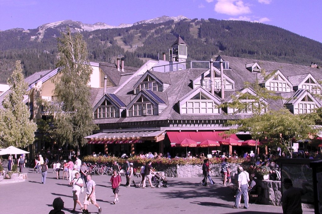
Located 125 kms from Vancouver, the inhabitants are primarily tourists who come for skiing and snow boarding in winter and mountain biking in summer. It provides all facilities for such tourists like boarding and lodging, restaurants and pubs etc. Actually this was the accommodation for the participants of the Olympics. Subsequently the facilities were modified to cater to the tourists. Famed for its Tyrolean design, it is indeed an impressive starting point for the Gondola and the ski facilities above.
Our Trip
Picked up from our Vancouver hotel, we had a scenic drive through some of British Columbia’s beautiful country side.
We had a small photo halt at a waterfall…the Shannon Falls
Shannon Falls
We reached Whistler by 10 am but were told that the gondola was temporarily shut due to inclement weather conditions.
We were a bit disappointed but our guide told us that it may still be open after noon.
Meanwhile, we visited Whistler Village. This compact, chalet-style pedestrian village at the base of Whistler and Blackcomb mountains; has lot of hotels, restaurants and other facilities. We walked around exploring the village which was once the accommodation for the participants of the Olympics.
Whistler village
During the walk around we had our eyes constantly looking out for announcements on the electronic display board about the resumption of gondola services.
The electronic display informing the status of various activities
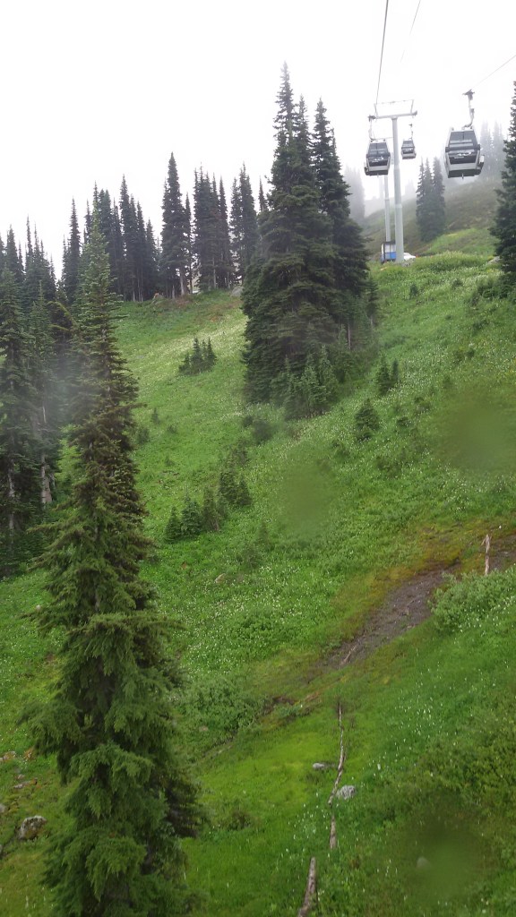
By noon, the announcement came that the gondola would resume service. With much excitement, we boarded the gondola.
This was a 30 minute ride to the peak.
The Gondola to Whistler peak
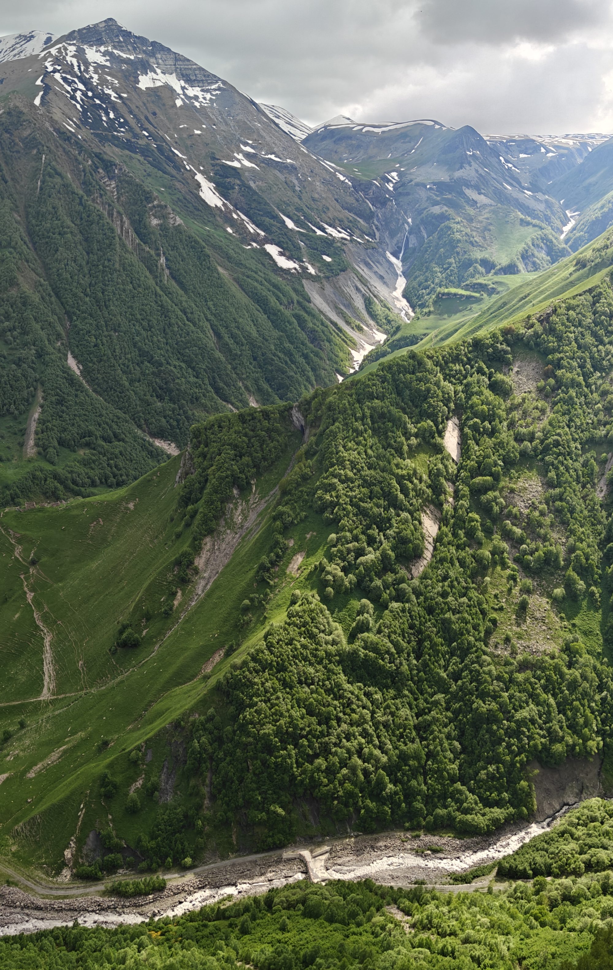
View of the peaks from the gondola
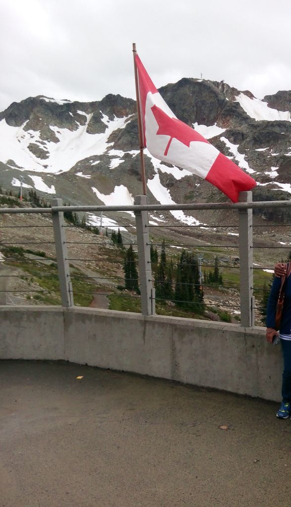
Whistler peak landing
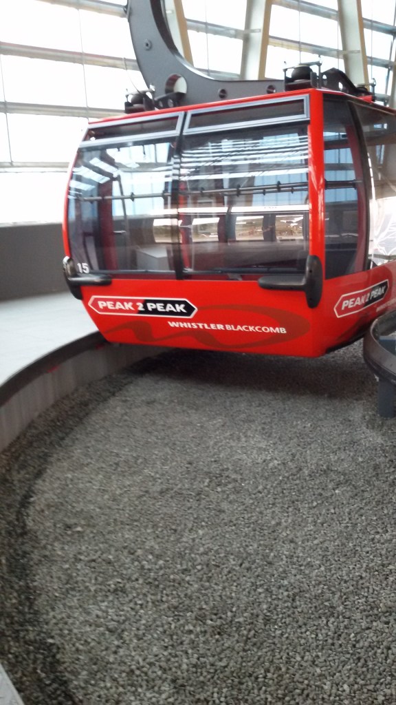
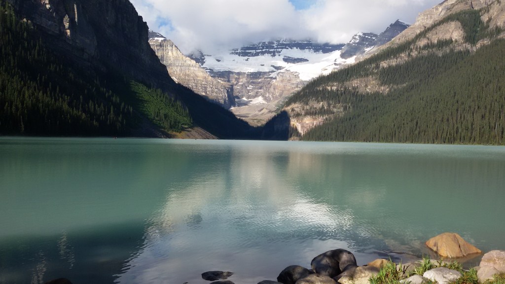
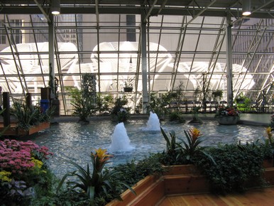
From there, we took the next gondola which is the peak to peak gondola. This runs between the Whistler and Blackcomb peaks. It has a glass bottom to enable greater visibility. It covers a distance of 4.5 km which makes it the longest connected Gondola system in the world.
Being suspended approximately 400 metres above the valley floor we had unique views of the Valley and the peaks and glaciers in Garibaldi Provincial Park. The glass-bottom cabin was ideal for a bird’s eye view of the creek and forests below. Accessible from the base of Whistler on the Whistler Village Gondola or from the base of Blackcomb on the Blackcomb Gondola; it gives a the 360 degree experience.
The Peak to Peak Gondola between Whistler and Blackcomb
View from gondola
View of Whistler village and the valley from the Peak to Peak gondola
This was really a unique experience. Since it serves a ski resort, the gondolas do round trips and we helped ourselves to two rounds of this exhilarating experience.
On the gondola we met another Indian couple and we had a nice picnic on the gondola munching some goodies which we exchanged.
After two rounds of this trip enjoying the breathtaking views, we returned to Whistler village in the smaller gondola and were driven back to Vancouver.
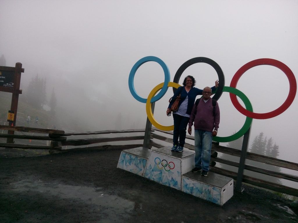
But not before a photo op ….
Our day among the clouds….on the Olympic podium
Well this brings us to the end of my series on Canada.
Now we move to Australia.…let’s meet next week down under…but not to forget…subscribe below
This beautiful place is the capital of British Columbia and is located on the southern tip of Vancouver Island 100 km from Vancouver city on the mainland.
Named after Queen Victoria; it boasts colorful gardens, a lovely harbor, magnificent architecture and a rich British ancestry, reflected in many historic buildings here …notably the Parliament building and Empress Hotel.
Having a temperate climate and being generally snow free; it is called the “garden city”.
A jewel in British Columbia, this place lost its commercial importance to Vancouver after the Canadian Pacific Railway terminus came up at Vancouver.
Our Trip:
We had booked a day tour of Victoria through Super Vacations and they picked us up from our hotel. We were driven to the ferry terminal and the bus boarded the lower deck of the ferry. The vehicles are parked in the lower decks of the ferry and passengers occupy the upper decks. Alighting from the bus in the lower deck , we climbed to the upper deck with a view to the open sea.
The lower deck on the ferry with vehicles and upper deck with passengers
After alighting from the ferry at Victoria we were given some time to explore the area. We walked around enjoying the beauty of this place.
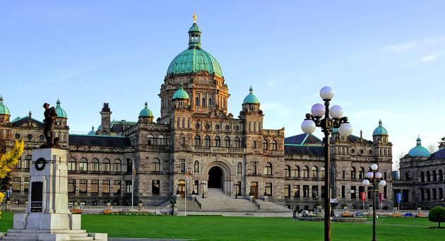
As mentioned earlier, there are a couple of historic buildings here…notably the Parliament building which houses the Legislative assembly of British Columbia and the Empress Hotel
Some pictures…
The Parliament Building
The Empress Hotel
Walking along the harbor front, there were some great views….
A seaplane….a common sight in Vancouver and Victoria
The Marina with yachts…
From March to October every year, thousands of whales migrate through the waters that surround Vancouver Island, making it one of the best locations for whale watching
A whale watching tour operator invites you with this lovely figurine
A beautiful street in Victoria
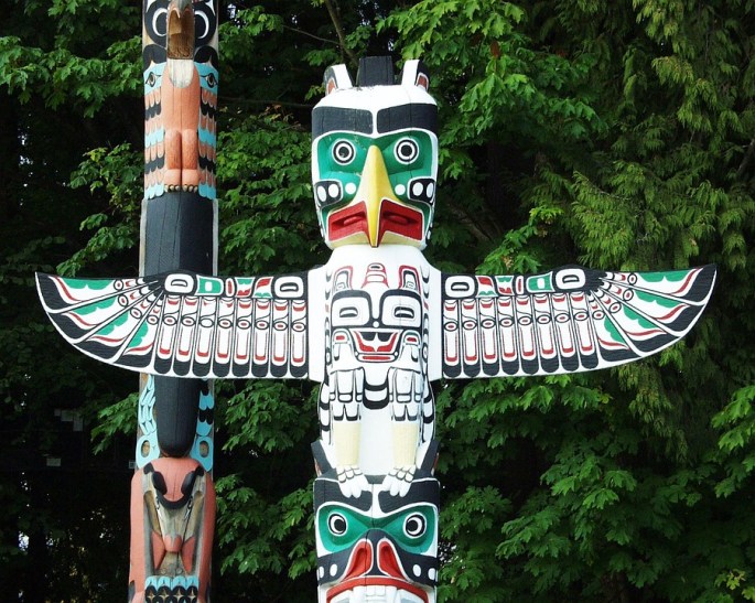
Another major attraction here is the Beacon Hill Park. Set in nearly 200 acres, this park is popular among the tourists and locals. It has woodland trails , tennis courts, ponds and of course is beautifully landscaped . It also houses a large totem pole.
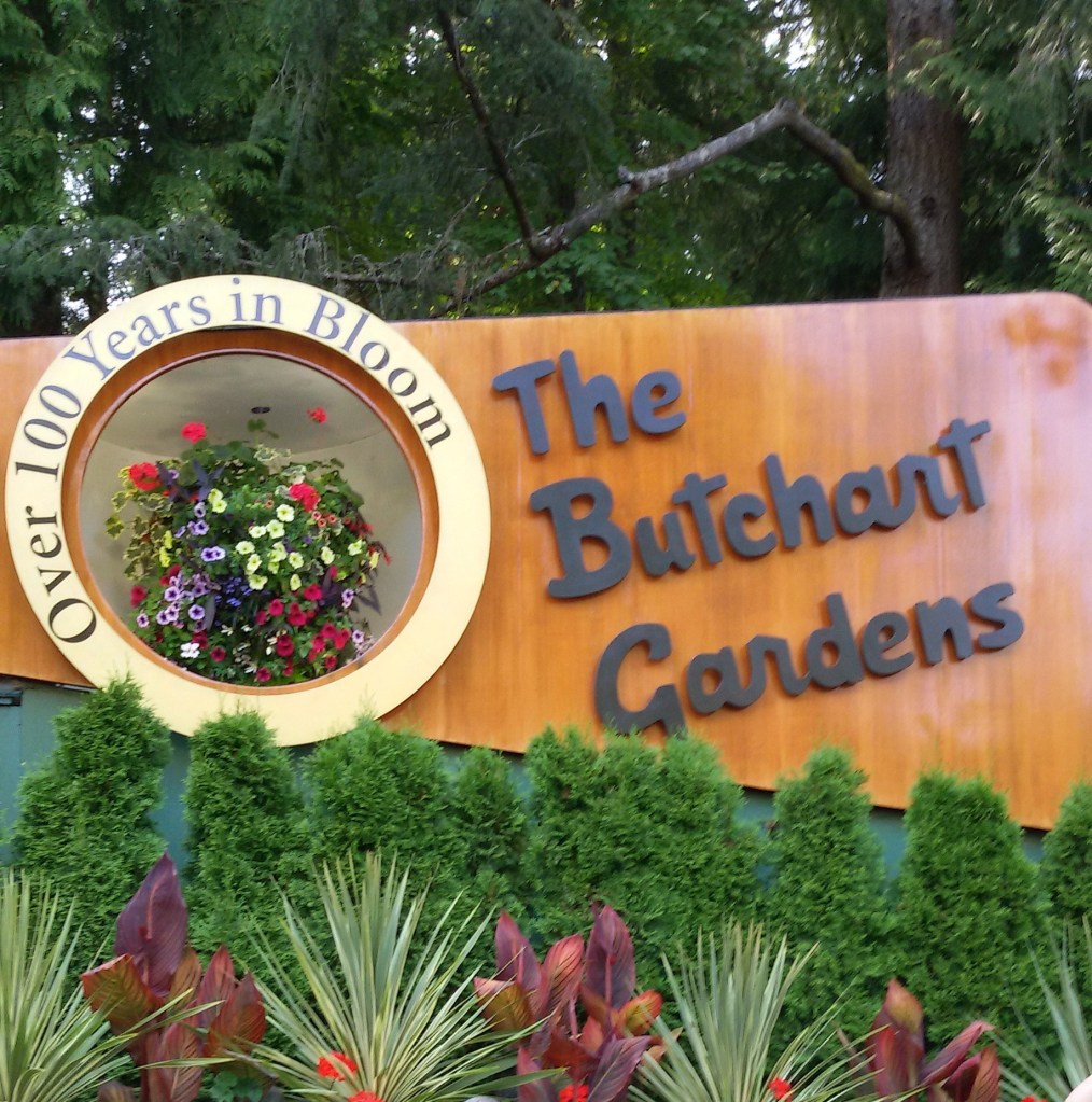
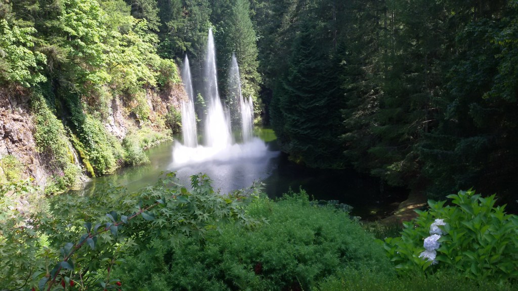
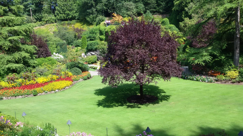
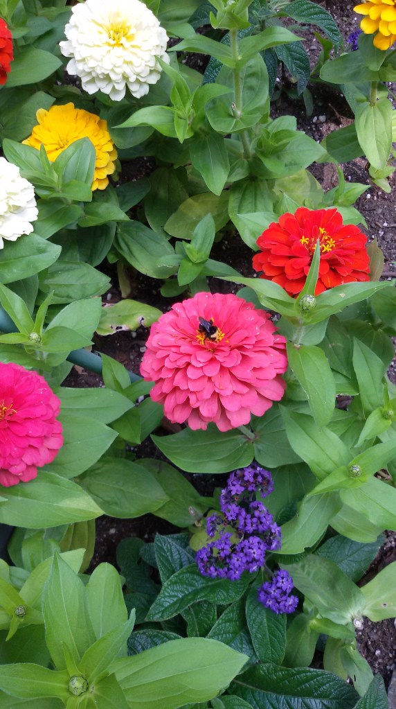
The Butchart Gardens:
After spending time along the water front, we were taken to The Butchart Gardens. It is designated a National Historic Site Of Canada.
This garden is actually a converted abandoned stone quarry. It is really an example of how proper planning and implementation can convert ordinary places into wonderful tourist destinations. It is actually a group of floral display gardens. There is a Japanese garden,Italian Garden, Rose garden etc.
The featured image in this blog is that of a walkway in Butchart Gardens..
Some pictures…
The Beautiful Entrance
After we finished seeing this beautiful garden, we were driven back to the ferry and sailed back to Vancouver…
A tiring but fulfilling day came to an end…but we still had another beautiful day ahead of us….the trip to Whistler…. See you next week at Whistler before we head for the southern hemisphere….
On a beautiful road trip from Calgary; enjoying the beauty of the Rockies, we arrived Vancouver late evening. After an overnight rest, we set off to sight see this jewel of British Columbia.
A short note on this beautiful city…
It is a major city in Western Canada in the province of British Columbia . It is one of the most ethnically and linguistically diverse cities in Canada. Though this area was inhabited by the indigenous people more than 10000 years ago, beginnings of the modern city started in 1867 around the present Gastown area and was called Gastown. The original site is marked by the Gastown Steam Clock. It was renamed Vancouver in 1886 by an agreement with the Canadian Pacific Railway. The city takes its name from George Vancouver a British Officer of the Royal Navy who explored and charted much of western coast including British Columbia, Washington and Oregon.
While forestry remains its largest industry, Vancouver is well known as an urban centre surrounded by nature making it a tourist destination. It has been nicknamed Hollywood North due to its popularity as a major film production centre in North America
The Port Of Vancouver is one of the biggest ports in North America making it a vital trade centre.
Vancouver is also home to many immigrant Indians,particularly Sikhs. Just like in Toronto, seeing a Sardarji pass by is a common sight.!! I had a nice experience of how many of them have got totally adapted and settled there. During one of our sightseeing trips, as we were approaching Vancouver, I saw a sardar on a tractor ploughing his field . I was given to understand that many farmers from the north particularly Punjab have taken to farming in Canada in a big way..
The highlights of Vancouver:
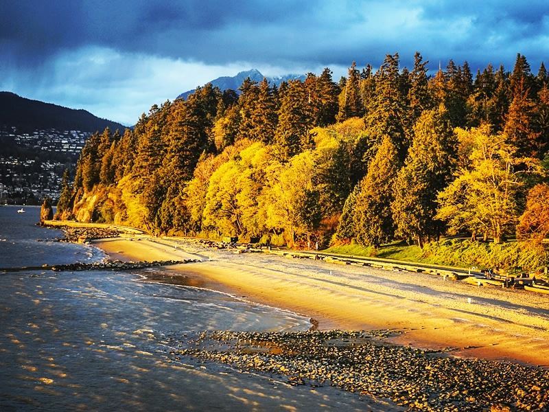
The Stanley Park is an iconic urban park in Vancouver spread over more than 1000 acres. Unlike many urban parks, Stanley park is not the creation of a landscape architect. It is an evolution of a forest and an urban place over many years. Much of the park still remains densely forested as it was in the early 1800s. It is estimated that there are close to half a million trees and many of them are hundreds of years old. There have been windstorms which have destroyed many trees too!! The park features forest trails, hiking paths, beaches, lakes, an aquarium and children’s play areas .
A beach at Stanley park ….note the onset of autumn on the leaves…
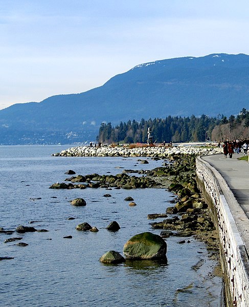
The Seawall is another highlight of Stanley Park.The walkway has been extended several times and is currently 22 kilometres from end to end, making it the world’s longest uninterrupted waterfront walkway. Cycling along this pathway is a popular activity.
The Sea wall
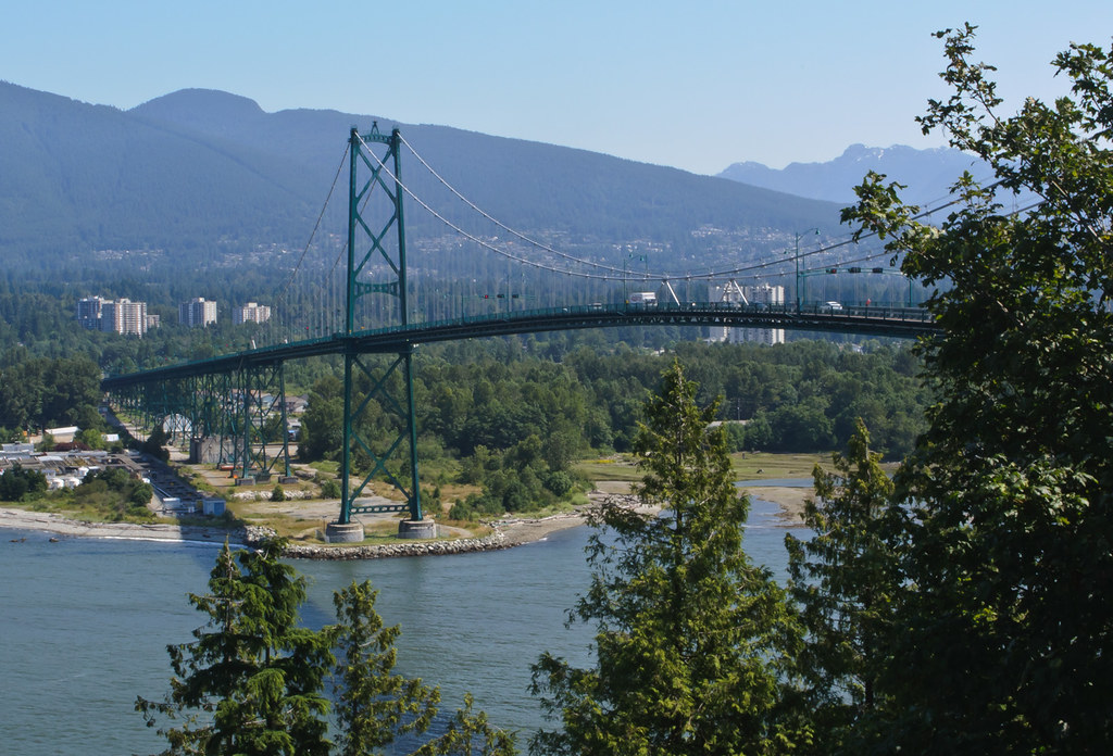
The Lions gate bridge that connects the city with the northern parts is also seen from this park.
Lion’s gate bridge
Another attraction here is the Indigenous Art area where there are carved wooden poles called Totem Poles. There are many such poles in the park and they represent the First Nation’s art work.
The featured image of this blog is that of a totem pole….just a tribute to the First Nation People and their artwork!!!!
Totem Poles
There is indeed no dearth of activity to follow at Stanley Park and it is a real urban oasis.No wonder that this park has been designated a National Historic site of Canada
Grouse Mountain:
Grouse Mountain is basically a Ski Resort . Located in North Vancouver, this winter wonderland offers skating, skiing and snowboarding. A gondola takes one from the street level to the summit where one can engage in any of these activities. Since the ski slopes are not particularly difficult, it offers great opportunities to learn skiing.
And for people like us who are not particularly interested in any of these, it offers great views of the city and surrounding areas of British Columbia. Besides, there are numerous shops and restaurants.
We visited in summer and so the ski activities were not there but we enjoyed the Gondola ride up and spent some time enjoying the panoramic views of the city from the top.Soaring to an altitude of 4,100 feet above sea level, the Gondola transports you to the apex of Grouse Mountain in about 15 minutes. Most local people were actually out there on a picnic! Of course there were lot of hikers too. Grouse mountain offers great hiking trails with great views. Zip lining, paragliding and eco tours are the other popular activities offered here.
The Gondola
View of Vancouver from Grouse Mountain
Paragliding at Grouse Mountain on a bright sunny day
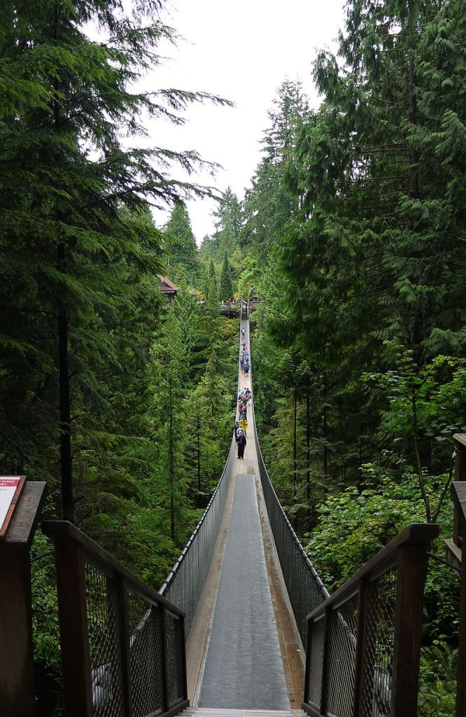
Another attraction in North Vancouver is The Capilano Suspension Bridge
This is a suspension bridge across the Capilano River. Around 70 metres above the river bed and 140 metres in length, this bridge is in private ownership. Originally made with hemp ropes and cedar planks, it was replaced with wire cables
The Capilano Suspension Bridge
Treetop adventures is an adventure activity offered at the Capilano bridge park. Suspension bridges built at a height lets one explore the tree tops and the ravines below.
Tree top adventures
There is also a cliff walk where one can walk along a semicircular bridge over the cliff and enjoy the beauty of the river below
The Cliff Walk
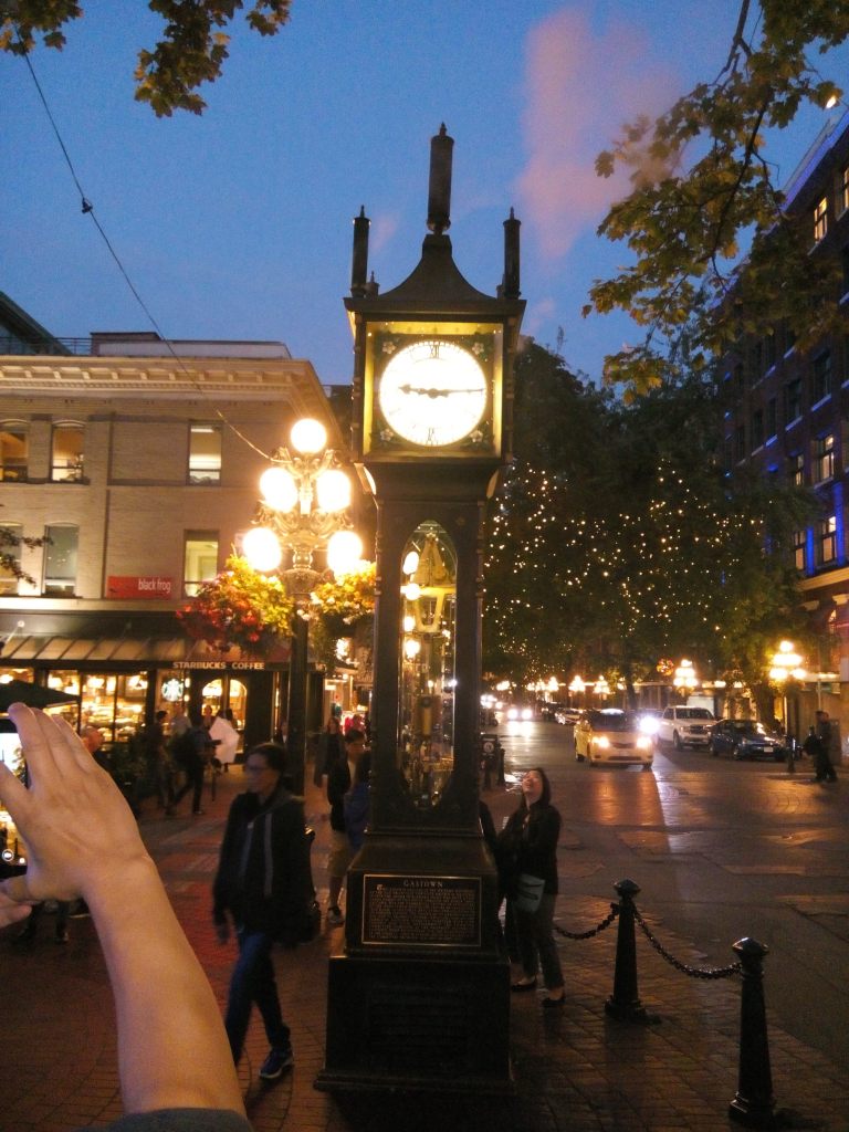
Gastown
The oldest part of the city, gas town is an area of restaurants, galleries and shops set in Victorian buildings. Heritage structures and cobblestone streets give the district its unique atmosphere. Gas town came into existence in 1867 when it was known as Gassy’s town after a man nicknamed as Gassy Jack. This soon evolved into Gas town.
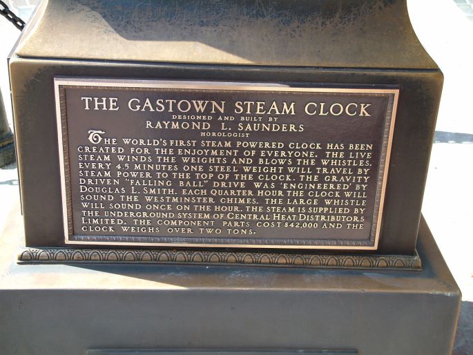
There is a famous Steam clock installed on the street here which gives out colored steam every 15 minutes.This is actually part of the steam heating system , as a way to harness the steam and mask the steam vent on the street.
The Steam Clock spewing pink colored steam
The plaque below the clock
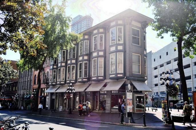
A typical street in Gastown
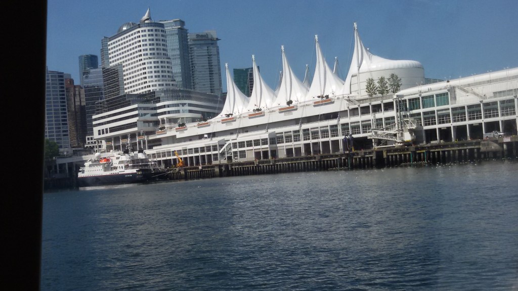
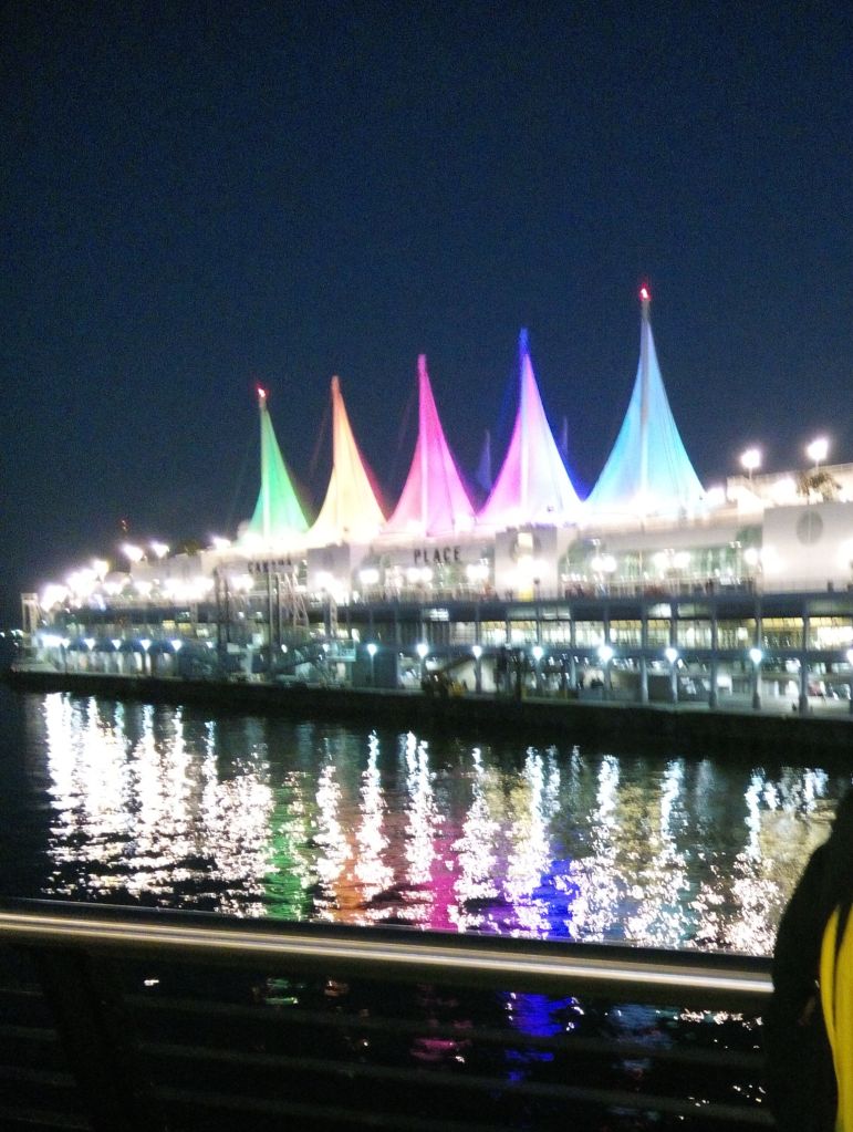
Canada Place
This architecturally designed structure along the shores of Vancouver; is part cruise ship terminal, part convention center and hotel and partly a hub for sightseeing bus tours. The unusual roof design creates the impression of a huge sailing vessel. If you happen to arrive in Vancouver by cruise ship, you will arrive here!!
Canada Place
Canada Place by night
There are regular sea bus services from here and we took a ride on one such sea bus.
The Sea Bus
The Vancouver skyline from the sea bus.
Well ; I hope you have got a sneak peek of this beautiful Canadian city. From Vancouver we also did short trips to Victoria and Whistler.
These two trips will be featured in my next two blogs which will bring us to the end of our Canadian Adventure.
For now, enjoy Vancouver and see you next week at Victoria…
The Athabasca Glacier in the Columbia Ice fields…that is our next destination.
The drive was amazing and picturesque…
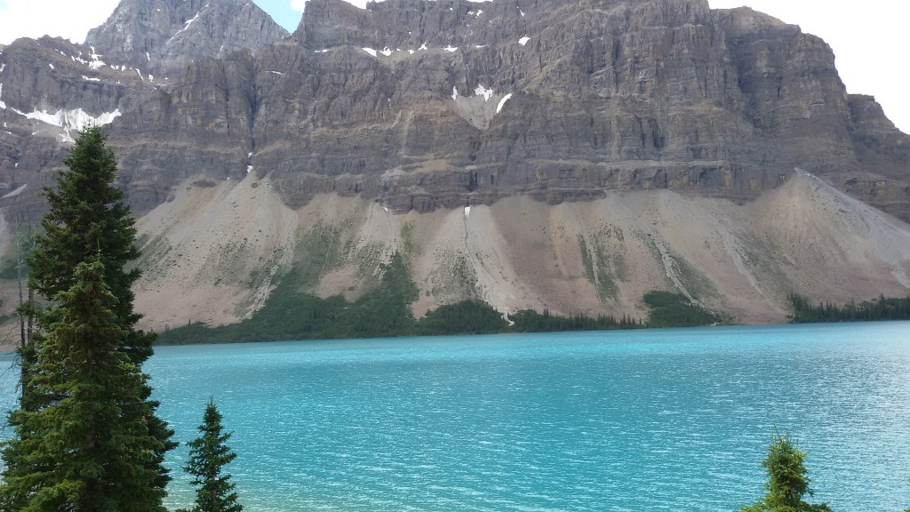
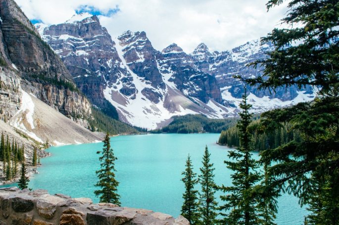
Bow Lake is a lake on the Trans Canada Highway as you drive from Lake Louise to The Columbia Ice fields. It lies at an altitude of 1920 meters and is formed by the melt water of the Bow Glacier. The beautiful turquoise color of the lake is due to the glacial till. It is one of the largest lakes in Banff National Park. We had a small photo halt by the Bow Lake. Some pictures…
The Beautiful BowLake…notice the color of the water…
After this beautiful view, we continued our drive to the ice fields and arrived at the Ice fields discovery center.
A small overview on this mighty ice field and glacier…
The Columbia Ice field is the largest ice field in the Canadian Rockies lying astride the Continental divide along the border of British Columbia and Alberta in Canada. It lies partly in Banff National park and partly in Jasper National Park . It has six major glaciers…Athabasca being one of them.
The Athabasca Glacier is one of the six principal toes of the Columbia icefield. This glacier has receded 1.5 km and lost over half its volume in the past 125 years at the rate of 5 metres per year of depth loss…..so much for global warming!!!
Being easily accessible from the Trans Canada highway, it is the most visited glacier in North America.
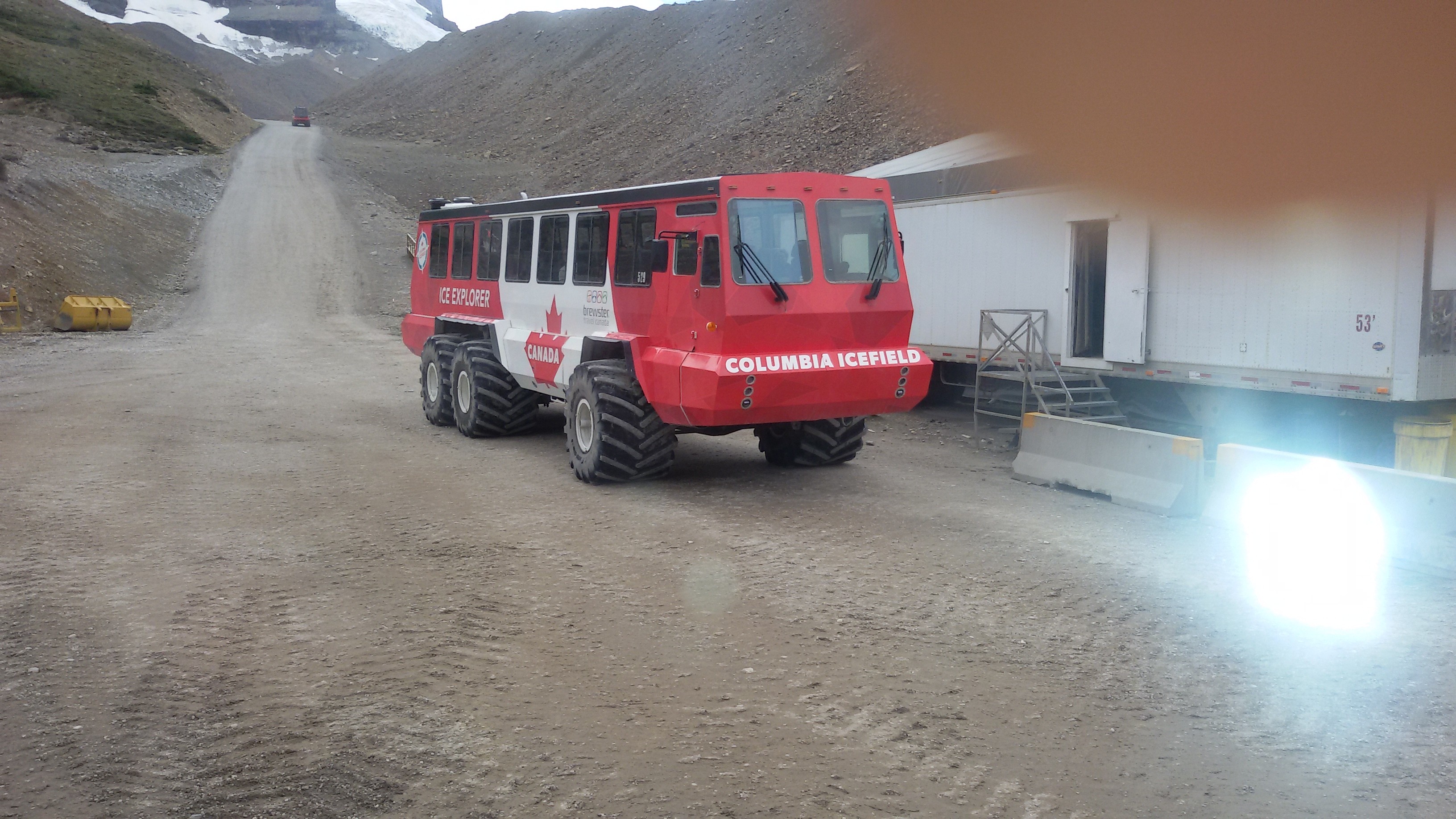
The Columbia ice field discovery center located across the glacier is used as a lodge for sightseeing on the glacier. Standard buses take you to the center . From there you board special snow coaches to reach the steep grades of the glacier
Riding on the glacier….a lifetime experience!!!….feel it as you read along…
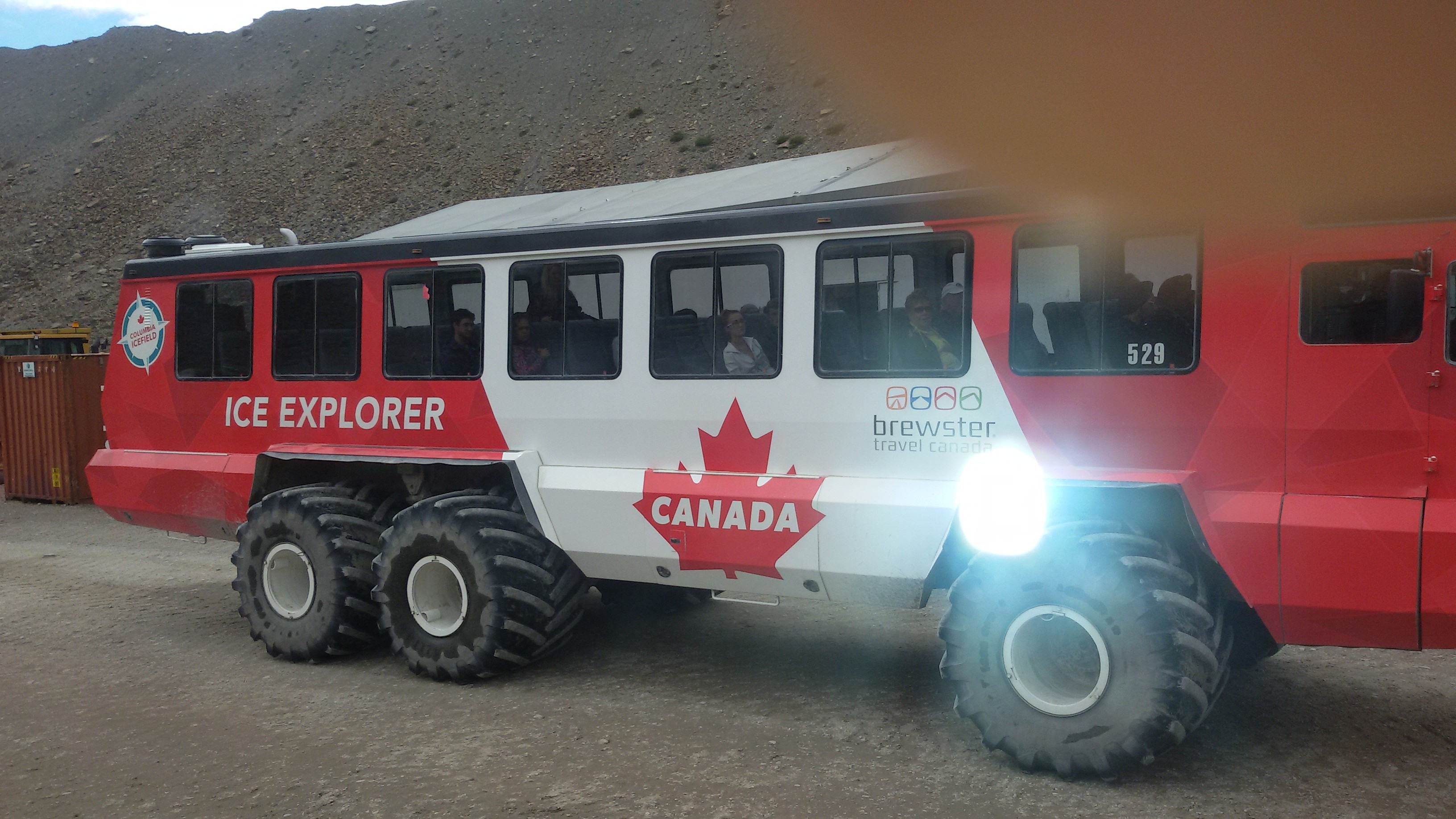
After a small break at the discovery center, we were asked to board the snow coaches. These buses have huge ribbed tyres which help them to manouver on the ice and prevents slipping and skidding. However, the driver warned us that it is going to be a bumpy ride and seat belts are compulsory on this coach. It does feel a little scary as this vehicle manouvers on the rocky hard ice making a lot of noise and throwing off a lot of ice as it moves towards the glacier.
Athabasca Glacier
The snow coaches used to reach deep into the glacier….note the strong tyres
The old snowmobile that was used ealier to reach the glacier…. now an exhibit
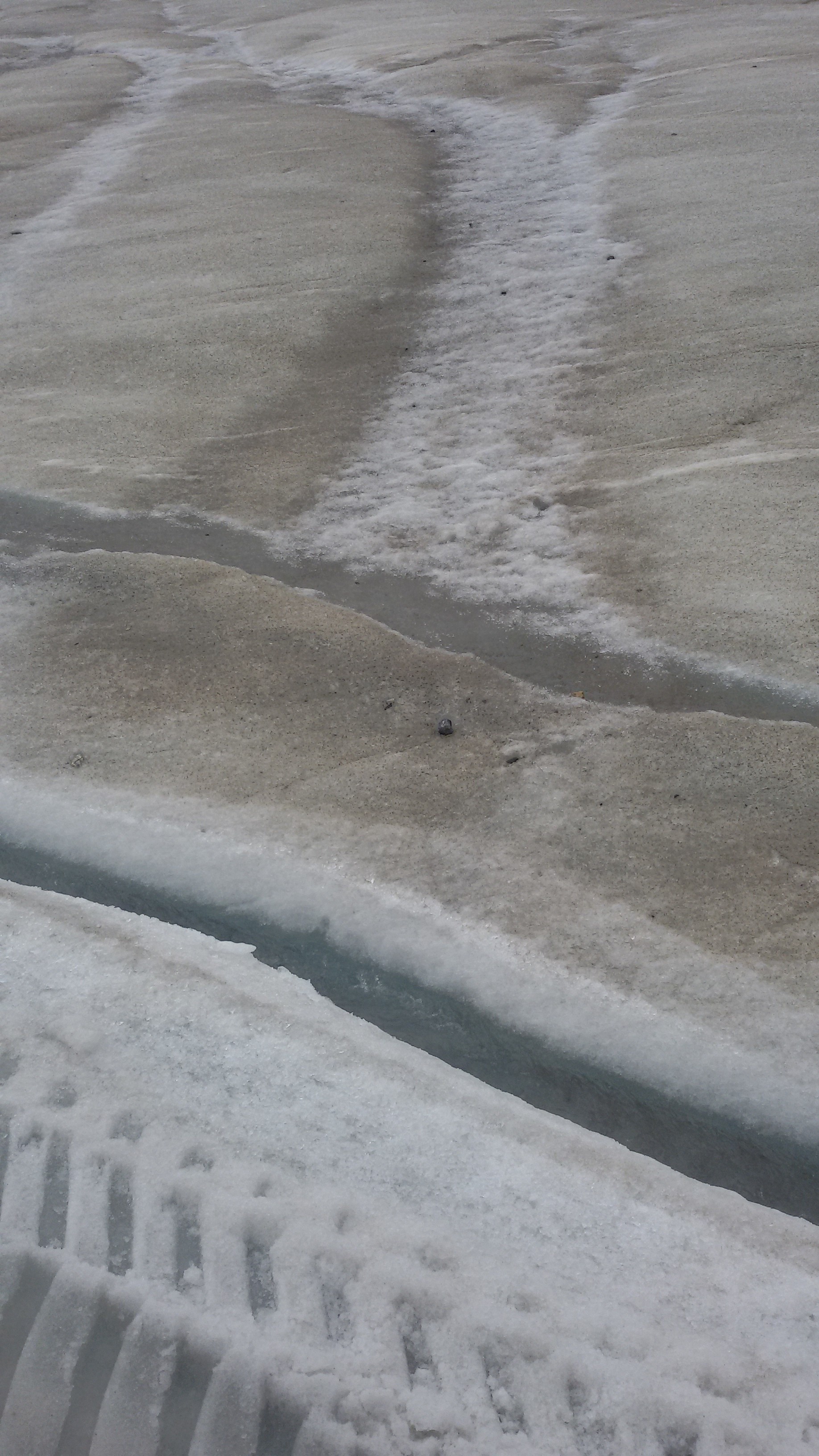
Once we were on the glacier, we played around in the snow . Another unique experience we had was drinking the glacier water. At places on the glacier, there were small pools of water…melted snow. Our guide assured us that it is very pure and it is safe to drink it. The snow surface may look dirty but it is due to the rock deposits and not dirt. So we collected some in a small bottle…it was sweet!!!….some unadulterated water from themelting snow on a mountain top!!!!!
The glacier floor and the potable water stream!!!
Though we managed to get some pictures here, the numbness of our fingers was an issue. You can well imagine how it must be; standing on sheets of ice and surrounded by ice every where!!
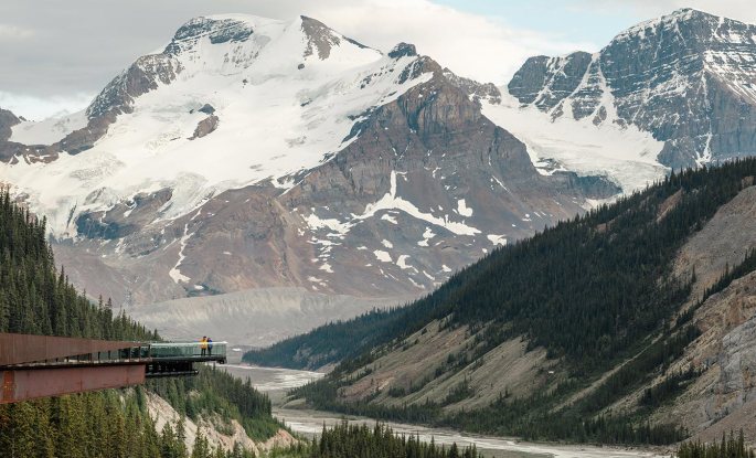
Our next destination was the Jasper Skywalk,...a large semicircular glass bottomed bridge that extends out from a cliff edge at a height of 300 mts from the Sunwapta valley floor. We walked for around a kilometre on the bridge. Wonderful unforgetable experience in life!!!….
The opening image of this blog is a picture of the Skywalk jutting out over the valley below
On the Jasper Skywalk…notice the Sunwapta valley below
The glacier sky walk experience is an audio presentation of the exhibits along the sky walk. As we enter the sky walk we are provided with an audio kit and as we walk along, we can get the description of the exhibits.The exhibits include wildlife, fossils and much more.
After finishing the sky walk experience, we were driven to Golden...a town in British Columbia enroute Vancouver from Calgary. Much of the town’s history is connected to the Canadian Pacific Railway and the logging industry. It is also closely associated with the Kicking horse river. With the development of the Kicking horse resort and associated adventure activities, it has transformed into a tourist destination with facilities for paragliding, hang gliding and mountain biking. The river flows from the glaciers of the Columbia ice fields and creates the Kicking horse canyon. The Kicking horse pass is the route taken by the Canadian Pacific railway to connect the high Rockies to the Bow Valley below
The Kicking Horse river got its name from a funny incident. James Hector ,one of the geologists of an expedition was kicked by his pack horse here. He decided to call the river The Kicking Horse river .
As an ecological, recreational, and historical jewel of the Canadian West, the Kicking Horse River enjoys the distinction of being the first British Columbia river to be recognized as a Canadian Heritage River.
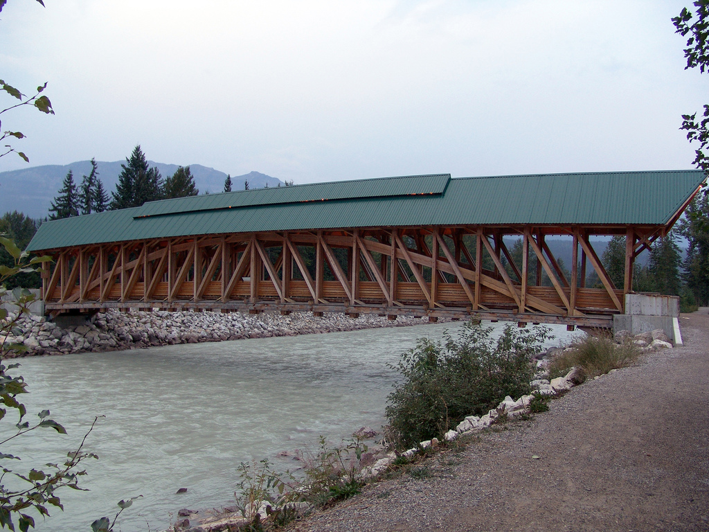
There is a cute timber bridge across the river. Built by the local timber framers, it is a popular photo location.
The Timber bridge across the Kicking Horse River
We were put up at Kicking horse ski resort and that was a bonus…living at a ski resort overlooking the ski slope.That was another unforgettable experience….the ambiance of a ski resort….with the room overlooking the cable cars that go to the ski slope….Being summer, there was no skiing activity but the ambiance was truly exceptional! The rooms are equipped with all kinds of skiing equipment too !!
The Kicking Horse Mountain and Ski Resort
View from our room at the resort
After the overnight stay at this wonderful resort, we proceeded next morning to Vancouver. The drive to Vancouver is also very picturesque.
We passed The Sushwap Lake and the town of Salmon arm
The Sushwap lake is a popular house-boating and water recreation destination. Salmon Arm is the urban centre on the lakeshore with a long curved wooden wharf and sandy beaches,
The Sushwap Lake
Enroute, we also visited the Last Spike…a historic site for the Canadian Pacific Railway.
The Canadian Pacific Railway was built between 1881 and 1885 to connect Eastern Canada with British Columbia in the west.It literally runs across the width of Canada .The Rail tracks were supposedly built from both ends and finally met at this place marking the completion of the track laying.
One can take a picture against a painting giving the appearance of driving the last spike into the track.
Driving the last spike …..
We arrived Vancouver by evening and checked into our hotel. It was indeed a great road trip from Calgary to Vancouver. By doing it as a road trip, we got to see the entire stretch of the beautiful Canadian Rockies. This is probably one of my best trips ever….the sheer beauty of the Rockies and British Columbia is something to be experienced at least once in a lifetime!!!
Rocky mountain peaks, turquoise glacial lakes,vast glaciers, a beautiful mountain town, abundant wildlife and scenic drives…this is what summarizes the beautiful Banff National Park. It lies along the Canadian Rockies between the provinces of Alberta and British Columbia in Canada.
Banff is also a designated UNESCO world heritage site.
Aperspective on Banff and the Rocky Mountains:
Banff National park is Canada’s first National park and encompasses more than 2500 sq miles of pristine wilderness.The Bow Valley which lies in the park is home to two small communities. The town of Banff at 4500 feet above sea level and Lake Louise which provides the base camp for hiking trails and other activities around the turquoise waters of Lake Louise itself.From here the Ice fields Parkway leads to truly remote destinations and glaciers and borders the Jasper National Park.
The Trans Canada Highway runs through the park and makes it easy to connect with Banff, Lake Louise and the Ice fields.
Wildlife
Banff is an all season destination with summer being most popular when you have ice free lakes and blooming alpine flowers.The park is home to grizzly bears, elk, moose ,coyotes and big horn sheep.The lakes have abundant trout and salmon.
Environmental Concerns
For some time, the park officials have been concerned about the effects of vast human presence in and around this region that could affect the wildlife. Besides the Trans Canada Highway, trains pass through it on the Canadian Pacific tracks which are a major east west link. Concerns on climate change with gradually increasing temperatures with melting and retreating glaciers also exist.
History
Retreating glaciers had left behind vivid blue lakes colored with glacial silt and canyons carved by water.
In 1883 employees of the Canadian Pacific Railway discovered a cluster of natural hot springs near the present Banff National Park. Squabbles over the ownership of these springs led the government to declare the area around the springs as a natural reserve.Subsequently more areas were added and it was declared a National park. That is how the beautiful Banff National Park was born…
Come on now….let’s visit this beauty
Calgary…the gateway to the Rockies was our starting point for this amazing tour of the Canadian Rockies with an online booking with a tour company.
Picked up at Calgary airport along with another family, we were driven by road to Banff.
A little bit about this amazing town…
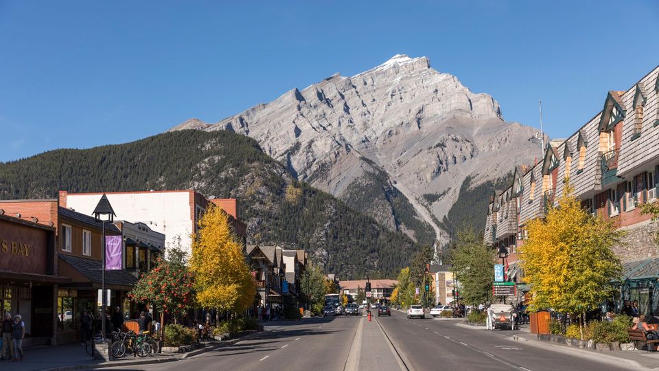
Banff is a resort town in Alberta, located within the Banff national park. Approximately 126 km from Calgary on the Trans Canada Highway,this resort town offers entertainment in summer and winter.The peaks of Mt Rundle and Mt Cascade dominate its skyline. The center of Banff town is Banff Avenue which is a thoroughfare with restaurants, boutiques, chateau style hotels, and souvenir shops.
Banff Avenue….the center of Banff town
A leisurely stay at Banff for two days is recommended to cover Banff town, the Gondola and visit to Lake Louise. Hiking, canoeing snowboarding horse riding and such activities add value to this beautiful town.
We visited in peak season and could not get accommodation at Banff. So we spent a few hours at Banff town walking along the avenue and savoring the beauty of the place.
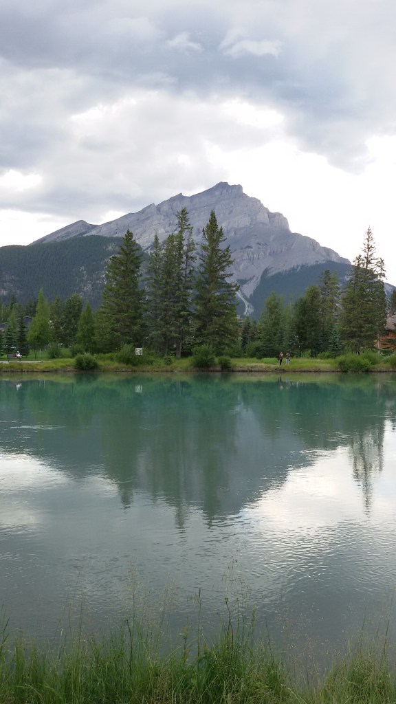
Our guide took us on The Bow River trail…( remember we had seen Bow River at Calgary).
It is a short walk from Banff Avenue ; a nice picnic destination with the Bow river, and benches to rest. Enjoyed the scenery and took some great pictures here.
The Bow River Trail
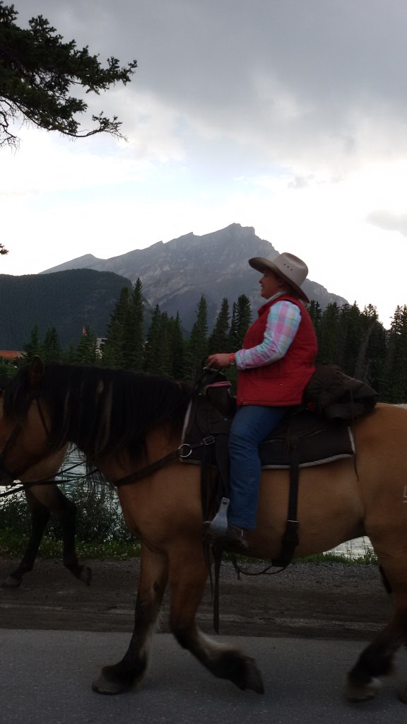
Horse riding along the Bow River Trail
A beautiful log house on the banks of Bow River
The Banff Upper Hot Springs have now been commercially developed and is located 4 kms from Banff Town. One can enjoy the hot pools and have great views of Mt Rundle. The water to the springs comes through cracks and crevices in Sulphur Mountain and hence lot of medicinal value is attributed to it.
Hot Springs at Banff
After the sightseeing at Banff, we were driven to Canmore…a small town close by for our overnight stay.
Canmore is also a beautiful place…some pictures..
Beautiful Canmore…
Next morning we left for Lake Louise...a hamlet in Banff national park, known for its turquoise, glacier-fed lake surrounded by high peaks. The turquoise color of water comes from the rock flour carried into the lake by the melt water from the surrounding glaciers.
This lake is converted into a skating rink in winter and has canoeing options in summer
Hiking trails take you to some of the peaks surrounding the lake
The lake is extremely beautiful and the scenery breathtaking…to say the least…
Have a look…
The beautiful Lake Louise with Victoria Glacier in the backdrop
Canoeing point at Lake Louise
The Fairmont Chateau Lake Louise Hotel
We spent some time by the Lake Louise and visited the Fairmont hotel that overlooks the lake.
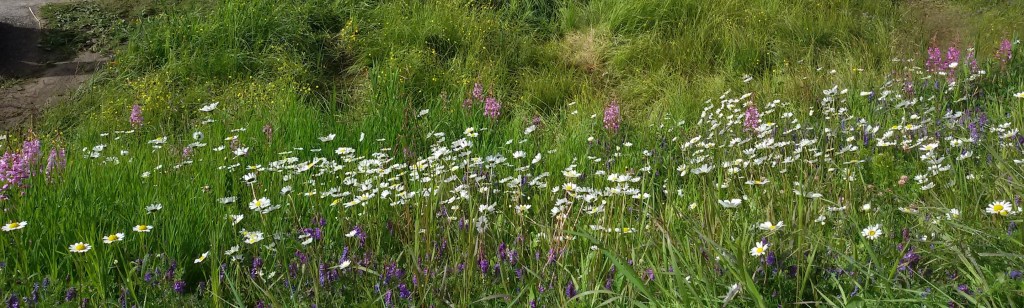
There was a carpet of alpine flowers on the banks of Lake Louise…take a look
??
The Alpine flowers on the banks of Lake Louise
There are a lot of hiking trails from Lake Louise which one can explore to reach various heights in the Rockies.
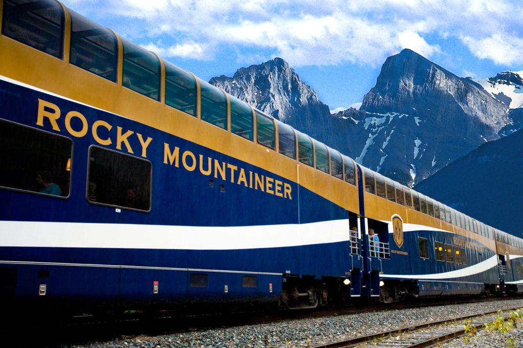
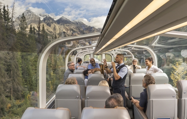
Another great way to explore the Rockies is to take the Rocky Mountaineer…..a luxury train running on the US Canada border . This train started in 1990 covers the provinces of British Columbia and Alberta in Canada and Colorado and Utah in the US and covers a distance of 4800 km. The glass dome of the train is suited for sightseeing and it also has a viewing platform from where one can enjoy the scenery. Meant primarily for sightseeing; this train runs only during the daytime and the passengers are accommodated at hotels along the way for the night. In 2007, Rocky Mountaineer was voted one of the most beautiful train journeys by National Geographic.
I don’t have to tell you the most important part….it costs a fortune to take this ride!!!
Never mind ….doesn’t cost a penny to see these beautiful pictures here…so take a look
Exterior and Interior of this mountain beauty…
Well I hope I have motivated at least a few of you to visit the Canadian Rockies…and if you thought its over…no its not….await some more awesome sights in next week’s episode on the Rockies …..the Athabasca Glacier…
Meanwhile don’t forget to subscribe below…doesn’t cost a penny!!!
This week we move on to the Canadian province of Alberta….to the city of Calgary…..consistently finding itself in the list of the neatest cities in the world!
Calgary is the third most populous city in Canada after Toronto and Montreal .One of the important financial centers in Canada; it is the center of the oil industry in Canada. It is located at the confluence of the Bow and Elbow rivers. Being close to the Canadian Rockies; it is a starting point for many tours to the Rocky Mountains and is often called the gateway to the Rockies.
The advent of Europeans in the late 19th and early 20th centuries led to the discovery of oil reserves charting a trajectory of development around Calgary.
Our trip to Calgary
After a late night arrival at our friends house in Calgary due to a delayed flight, we started the day a little late.
Our friends took us on a picnic ….with a nicely packed picnic basket et all….we set off like excited teenagers to downtown Calgary.
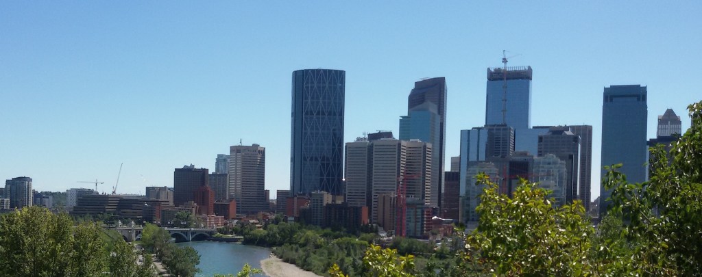
Enroute, we saw downtown Calgary across the Bow River
Downtown Calgary…view across the Bow River
The Bow River
Next we headed to Peace Bridge…a unique looking bridge with a double helix structure across the Bow River. It has the nick name “finger trap bridge “for its similarity to the finger trap puzzle.
This bridge connects downtown Calgary with communities across the bow river. It was designed to accommodate the increasing numbers of commuters to and from work and has walking and cycling tracks. It is unique in that no beams or cables are included in the plan and is designed to support its own weight.
The openingshot in this blog is of the lit up Peace bridge.
The Peace Bridge
Peace Bridge….another view
We set up our picnic basket near the bridge and had a nice treat of Indian food.
Picnic by the Peace Bridge…some unforgettable memories….
Next we headed to Prince’s Island Park…a park built on an island in the Bow River. This park is an urban oasis and part of a pathway linking both sides of the river ….with a constructed wetland designed to treat storm water before it enters the Bow River!!!
This is a perfect example of River conservation…and how urban planners can effectively use the existing natural resources and make them sustainable over periods of time…at the same time; providing entertainment avenues to the locals and increasing the tourism potential. A lesson for us indeed!!!!!
Some pictures from Prince’s Island Park
Then we went to downtown Calgary and visited a mall where we had some goodies and coffee.
Devonian Garden is an indoor garden in downtown Calgary. This park is completely enclosed with glass and covers an area of 2.5 acres on the top floor of The Core Shopping Mall. It is an urban oasis and has play areas for children. It is also a popular venue for weddings. Some pictures…
Devonian gardens
Calgary Tower
An iconic structure in Calgary, it was originally called Husky Tower.It is an observation tower in downtown Calgary built in 1967 to celebrate Canada’s centennial.
Calgary Tower and Observation deck
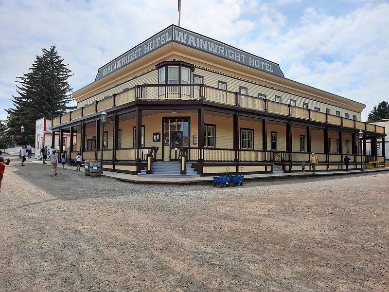
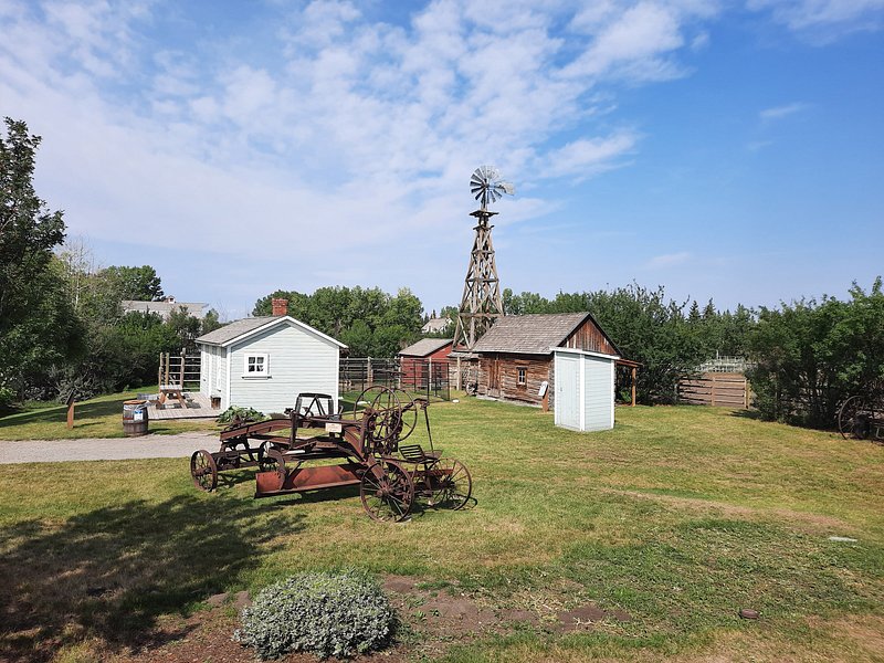
Another important tourist destination here is the Living History Museum or Heritage park historical village.Many of the buildings are historical and were transported to the park to be displayed. Most of the exhibits are genuine artifacts.The exhibits span Canadian history from the 19th and early 20th centuries
After an enjoyable day of sightseeing, we headed back home for some rest before we hit the best part of Alberta…The Canadian Rockies…
Quebec city sits on the St. Lawrence River and is in the predominantly French speakingQuebec province. Among its main distinguishing characteristics are its narrow cobblestone streets, stone buildings, fortifications, and rich French Canadian culture.
Brief history of Quebec and its french connection..
Canada is predominantly an English speaking country with Francophone communities throughout its provinces. French is the native language of 20 % of Canadians.Most native french speakers live in Quebec where it is the official language.
In the 16th century, Cartier ventured across the Atlantic Ocean in search of a route to Asia and landed at Newfoundland and mapped his route along the St Lawrence River. He tried to establish a French colony but was resisted by the aboriginals.
The name Canada originated from Kanata …the indigenous word for village. Cartier used this name for the French colony that developed along the St Lawrence River.
French Colony was established by the early 17th century in eastern Canada by Samuel Champlain and Quebec city was established in 1608. By 1642 a settlement called Ville Marie was established which subsequently became Montreal.
The 18th century saw French Canada fall to the British rule and consequently French lost its importance. Gradually Canada emerged as a federal state and it was divided into two provinces..Upper Canada(now Ontario) and Lower Canada(now Quebec). French was subsequently established as the official language in Quebec and many of the Eastern Maritime Provinces of Canada. Thus many of these places have French as the official language and that makes it a little difficult for non French speakers like us to visit and move around.
Come along to see the city….
Old Quebec city is a UNESCO heritage site and lies within fortified walls…the only city in North America to be so…
Being located in a hilly slope, the city is divided into upper town and lower town connected by funicular railway.
A typical Quebec street…the funicular railway seen in the backdrop..
We reached Quebec by noon and first visited the Quebec Tower ( Observatoire de la Capitale)from where you get a 360 degree view of the city. This is actually on the 31st floor of what looks like an office building!!!
From the tower, the old city can be clearly seen behind walls.
View from tower… St Lawrence River, Chateau Frontenac Hotel and walls of old city
After getting a view of the city from the tower, we went to the banks of the St. Lawrence River.
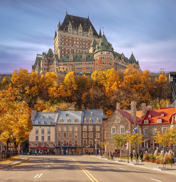
The Dufferin Terrace, a long wooden promenade located along the banks of the St. Lawrence River is one of the main attractions here. The Château Frontenac, a hotel that was initially built for the railways and is a luxury hotel today, is a landmark of Quebec. In the summer, musicians and street entertainers perform on this wooden promenade
The opening image of this blog features this hotel .
With its breathtaking view of the Château Frontenac, as well as of the St. Lawrence River and surrounding area, the Dufferin Terrace is the perfect spot to take beautiful pictures.
The Dufferin Terrace with The Chateau Fontenac Hotel in the background
A street singer and the canons along the river side on Dufferin terrace
From the Dufferin terrace area, we walked around the streets of Old Quebec. This place has an old world fairy tale charm about it. The narrow cobble stone streets with stone buildings gives it an ancient look. There are horse drawn carriages here which add to the old world look….and there are sightseeing tours on horse carriages
A family takes a joy ride on a horse drawn carriage..old world charm
A sightseeing bus….modern times
We walked along the cobble stone streets of old Quebec soaking in the old meets new feel….
There were lots of street musicians singing or playing various instruments…lost in their own little worlds….not affected by the passers by ….
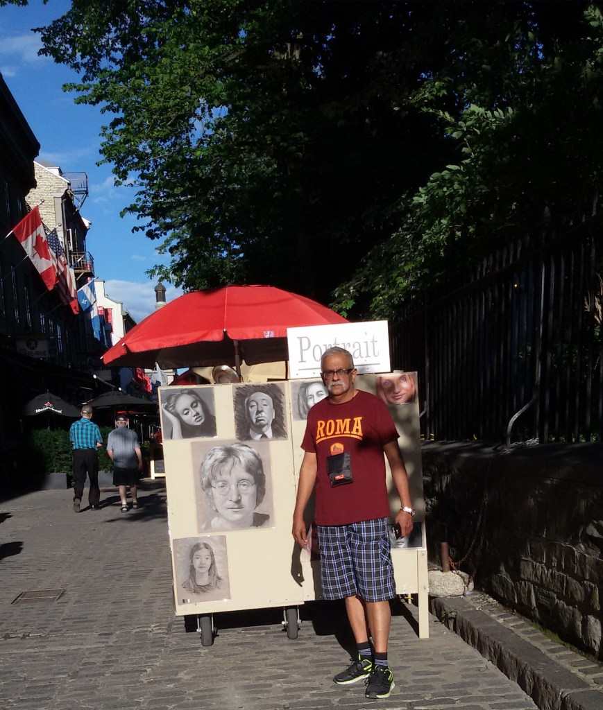
There were street artists….some doing general paintings and others making portraits of willing clients….
A street side artistic…portrait maker
All in all it was a heady mix of history, culture, fun, art and tourism!!!!
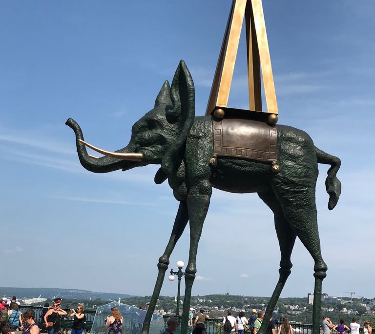
Talking of art…there were some nice sculptures by Salvador Dali at the Dufferin terrace… take a look
After a long day of sightseeing we retired to the hotel for the night.
Next morning we had yet another interesting trip to do…the Thousand Islands Cruise…
This is a one hour cruise on the St Lawrence river to see this archipelago of islands.
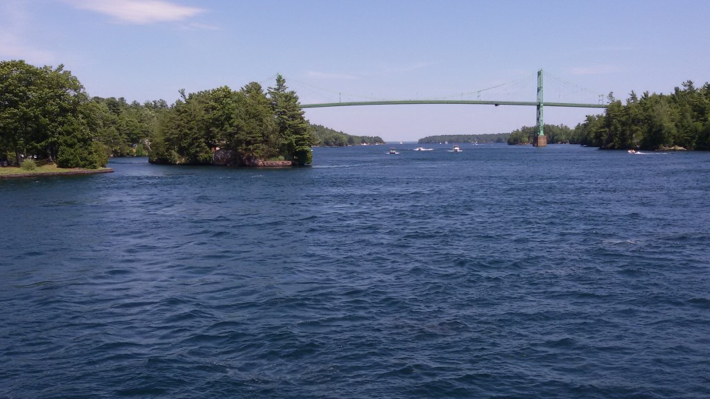
The Thousand Islands are a group of more than 1,800 islands in the St. Lawrence River, straddling the border of the U.S. and Canada.The islands vary in size from over 100 sq kms to smaller ones occupied by a single residence or the uninhabited ones with just a few rocks. The criterion to be included in the island count is that it should have at least one square foot area and support at least two trees!!!
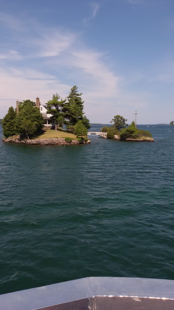
A fashionable retreat for the elite in the late 19th century, today the area is a hub for outdoor activities. It is home to elaborate island mansions such as the German-style Boldt Castle on Heart Island, and Singer Castle on Dark Island, with its Gothic windows and secret passageways.There are a variety of recreational activities available here for the tourists….fishing, diving, hiking, being some of them
Some of these islands are privately owned and have mansions belonging to the elite. There are some extremely small islands and many are connected by small overbridges. There are two islands connected by a bridge here, where one island belongs to US and another to Canada.
The Thousand islands International bridge connects Ontario province in Canada with New York state in US.
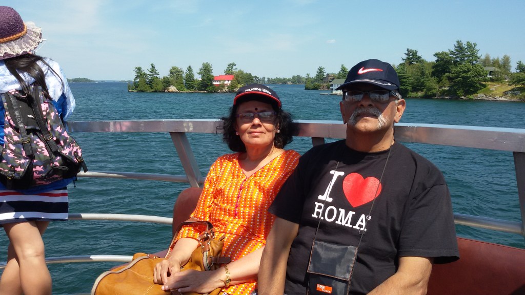
Some pictures from the thousand islands….
On board the cruise
The Thousand islands International bridge .
Two tiny islands with a single mansionconnected by a cute bridge
Boldt Castle
After the cruise we were picked up by our tour company and driven back to Toronto…after a 3 day roundup of some heritage, historic and cultural places in Canada…
Next week we move on to Calgary…in Alberta Province famous for its Rocky mountains…
We wanted to visit some of the important cities in Canada from Toronto. After some scouting around online, we narrowed down on a tour agency called Tours 4 fun. They were offering 3 day trips to these cities and so we booked with them. They cater predominantly to Chinese tourists . They did a good job overall.
We were picked up by the tour bus at Mississauga near the Chinese shops. Our first halt was at Kingston.
Kingston is a city in Ontario in Canada on the banks of lake Ontario at the mouth of the St Lawrence river. It is known as The Limestone City…due to its 19th century limestone architecture. It was a military post in the 16th century. It is called Kingston in honor of King George III. It was the first Capital of Canada . It prides itself in having a robust healthcare system and is home to a variety of educational institutions. At Kingston we saw the city hall,good lakeside homes like retirement communities, a marina and a locomotive exhibit.
The city hall is an imposing piece of neoclassical architecture with a prominent dome.It is the seat of local government in Kingston. It overlooks Lake Ontario which has a beautiful marina with lots of yachts anchored there.
The City Hall and Lake Ontario
An antique coach and a locomotive exhibit at Kingston
After spending about an hour in Kingston, we headed to Ottawa.
Ottawa city, the capital of Canada is located in Ontario on the banks of the Ottawa river.
We reached Ottawa by noon. After lunch at a restaurant , we proceeded to see the Canadian Parliament.
The Parliament is located on Pariament Hill on the banks of the Ottawa river in downtown Ottawa. In the foreground of the parliament building is the flame and water monument called Centennial Flame. The flame burns continuously and works with natural gas bubbling through water cascading underneath. The flame prevents the water from freezing in winter. It commemorates the hundredth anniversary of the Canadian Confederation.
The Canadian Parliament
The Centennial Flame
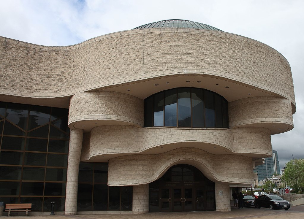
Next we visited the Museum of civilization also called Canadian Museum of History on the banks of the Ottawa River. It houses thousands of artifacts, archival documents, works of art and other ancient material relating to the indigenous people of Canada to the present time. Interactive shows related to Canadian History is another attraction at this huge complex.
Museum of Civilization
The Ottawa River seen from the museum
We next visited the Notre Dame Basilica…the largest and oldest church in Ottawa.
The Notre Dam Basilica
After the visit to the church, we proceeded to Montreal for an overnight stay.
Montreal is located in Quebec province and is predominantly French speaking.
We were put up at a hotel and next morning, we set off sightseeing Montreal.
Approaching Montreal….
We visited St Joseph’s Oratory. It is the biggest church in Canada built in ItalianRenaissance style and has a copper dome which is one of the biggest church domes in the world. It is a National Historic Site. It is located on the highest point in Montreal located on Mount Royal.The insides of the Basilica is decorated with intricately carved murals. On display at the Basilica is a wall covered with thousands of crutches from those who were purportedly healed by the divine healing powers of Brother Andre.
Some restoration work was in progress when we visited and that can be seen in the picture
St Joseph’s Oratory
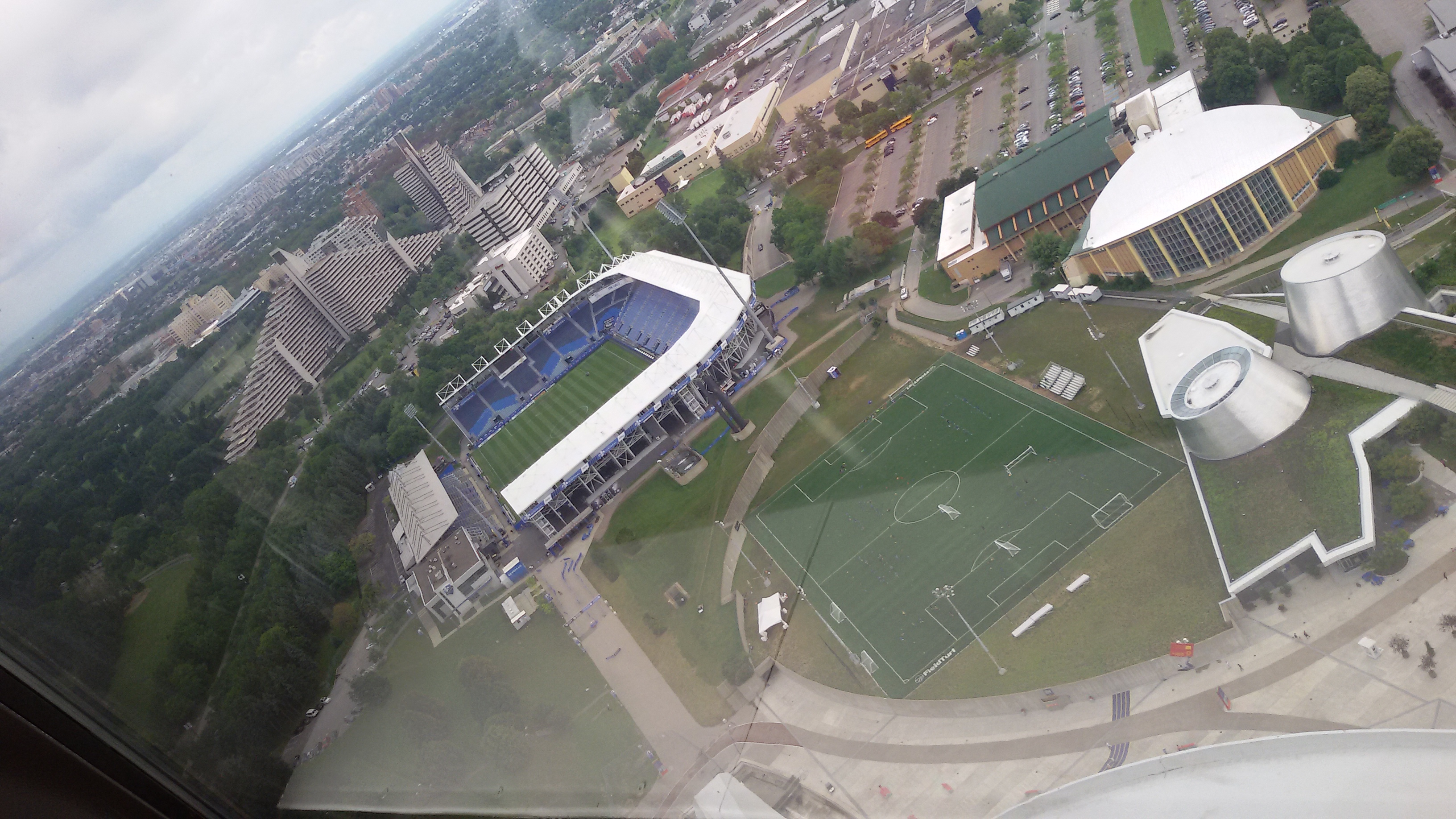
Next we visited the Olympic Tower….now known as Montreal tower, this is part of the Olympic games complex built for the 1976 Olympics in Montreal.…..and is the tallest inclined structure in the world.
This tower is inclined more than the Leaning tower of Pisa and the cables that hold the retractable roof of the Olympic stadium is suspended from the tower.The opening shot of this blog shows this …..
There is an observatory in the tower that can be accessed by an inclined elevator from where one gets a view of the Olympic village.
Montreal Tower and view of Olympic village from Montreal Tower
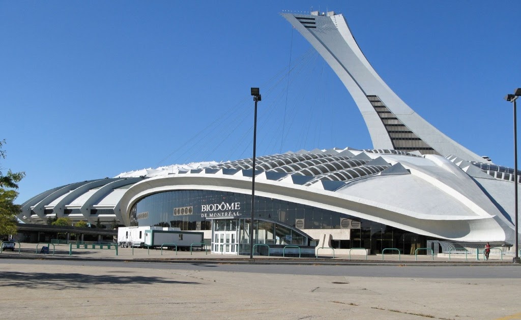
The Biodome which is located adjacent to the tower was our next destination.
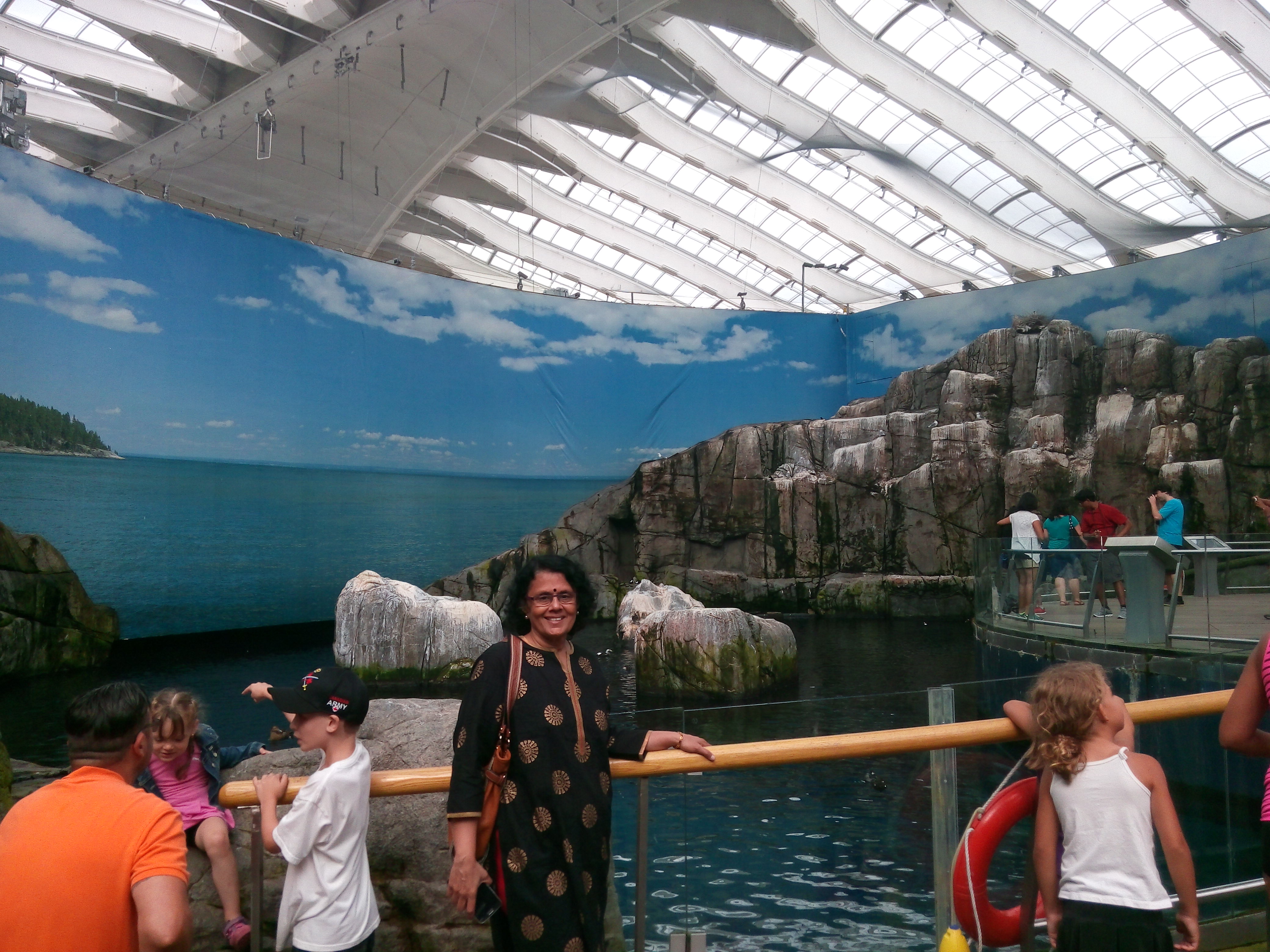
This housed the velodrome for the 1976 Olympics and the track cycling and judo events were held here. After the Olympics, it was converted into the Biodomewhich showcases four miniature echo systems.These are filled with plants and animals found in these eco systems and visitors can walk through the different ecosystems and enjoy nature under a roof. Some of the featured ecosystems are…Tropical forest, Laurentian Maple forest, St Lawrence Marine,Labrador coast and sub antarctic islands.
So one can imagine….the range of plant and animal life residing there…from the parrots and monkeys of tropical forests to the fish of St Lawrence River to the penguins and puffins of subantarctic zone…Its a different world inside the Biodome…
The Biodome from outside and inside
Some inhabitants of the Biodome
After visiting the Biodome, we continued our journey across Canada to yet another iconic city...Quebec…
This week we do Toronto. Since we were at Toronto for a month, there were lots of things we did and this blog is a sum total of this. Unlike in my previous blogs, here I narrate various visits and my regular readers may notice that it is not a continuous flow.
First thing that struck me was… as you alight from your flight and enter through the gates into the terminal….you see a large board…You are Welcome in Canada…this is something which I found unique….this board would surely have reassured many a foreigner stepping on Canadian soil with trepidation and uncertainty.This would apply more to potential immigrants who would like to chart a future in Canada. Very Immigrant friendly country!!!
We landed there at night and woke up after a long sleep overcoming jet lag.As I opened the front door and looked out, I wondered if I had landed in Canada or Punjab? Every person I saw was an Indian and most of them Sikhs…that’s how much this city has embraced our people and vice versa. Indian seniors sitting on garden benches and chitchatting while soaking in some sunshine to beat the biting cold, is a common sight.Travelling by public transport, you often hear telephonic conversations in Hindi and Punjabi. So if any of you travel to Canada…particularly Toronto, have no worries of feeling alien….you will feel very much at home.
OK…now let me get into specifics….
First let me introduce you to our friends in Toronto who were so kind to host us and also take us along sight seeing.
Our friends at their beautiful house in Brampton, Toronto
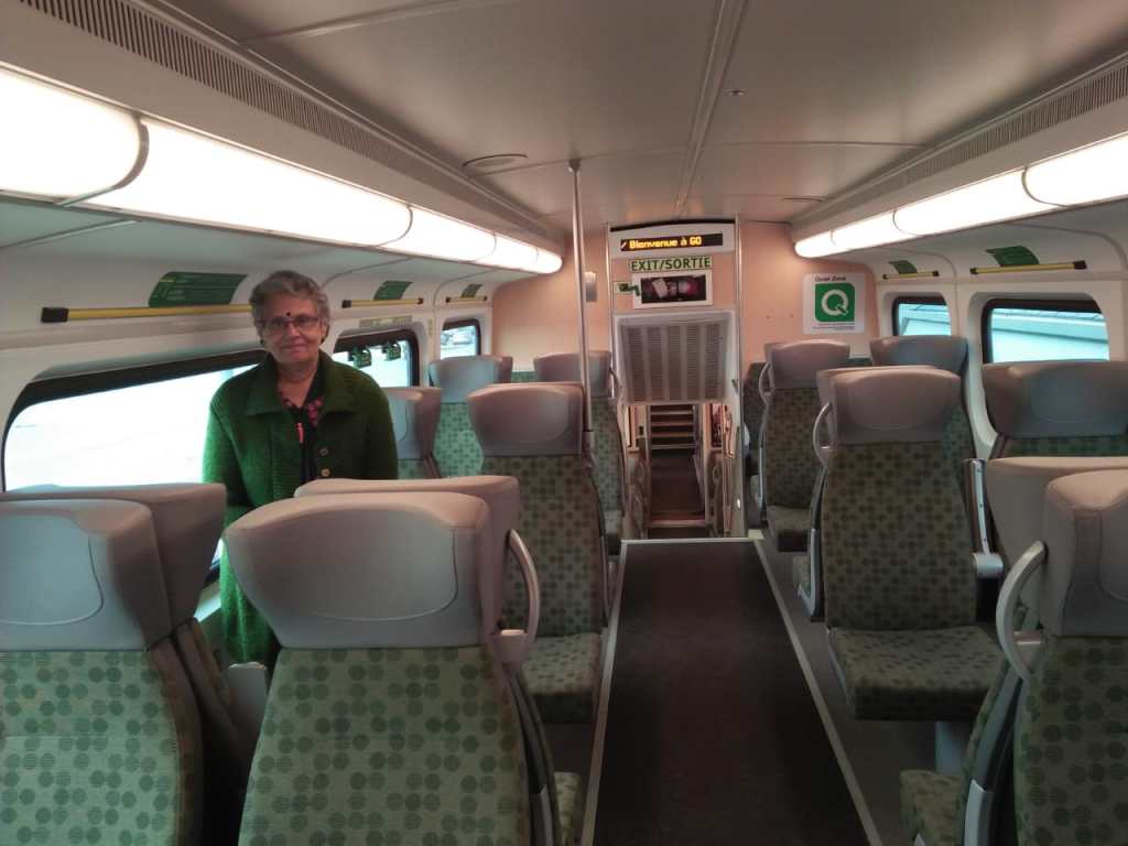
We did a lot of commuting in Toronto, partly by public transport and partly driven around by our friend. Here are some pictures of the local buses, trains etc…just to give a perspective…
The local city bus and bus stop
The double decker GO Train outer and inner view
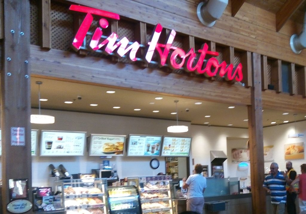
For us Tim Horton’s is synonymous with Canada….where ever we traveled, we enjoyed their coffee and snacks. This restaurant chain kept us pepped up with energy during our long trips many times…So I decided to include a picture of one of their outlets for all of you to see. We sort of got addicted to their awesome coffee and I particularly enjoyed the pumpkin spice flavor which is associated with fall…the season we were there….
A Tim Horton’s Outlet
Let me start with our visit to Downtown Toronto .
We were dropped at the Toronto airport by our friend. From the airport, we took the Union Pearson Express train to downtown Toronto.
After getting down at Union Station, we explored the place on foot and decided to do a hop on hop off tour. Booked our tickets from the agent near the station and boarded the double decker bus with an open upper deck.
The Sightseeing bus
The bus wound its way through the streets of Toronto and we were in front of the
CN Tower… the iconic structure in Toronto.
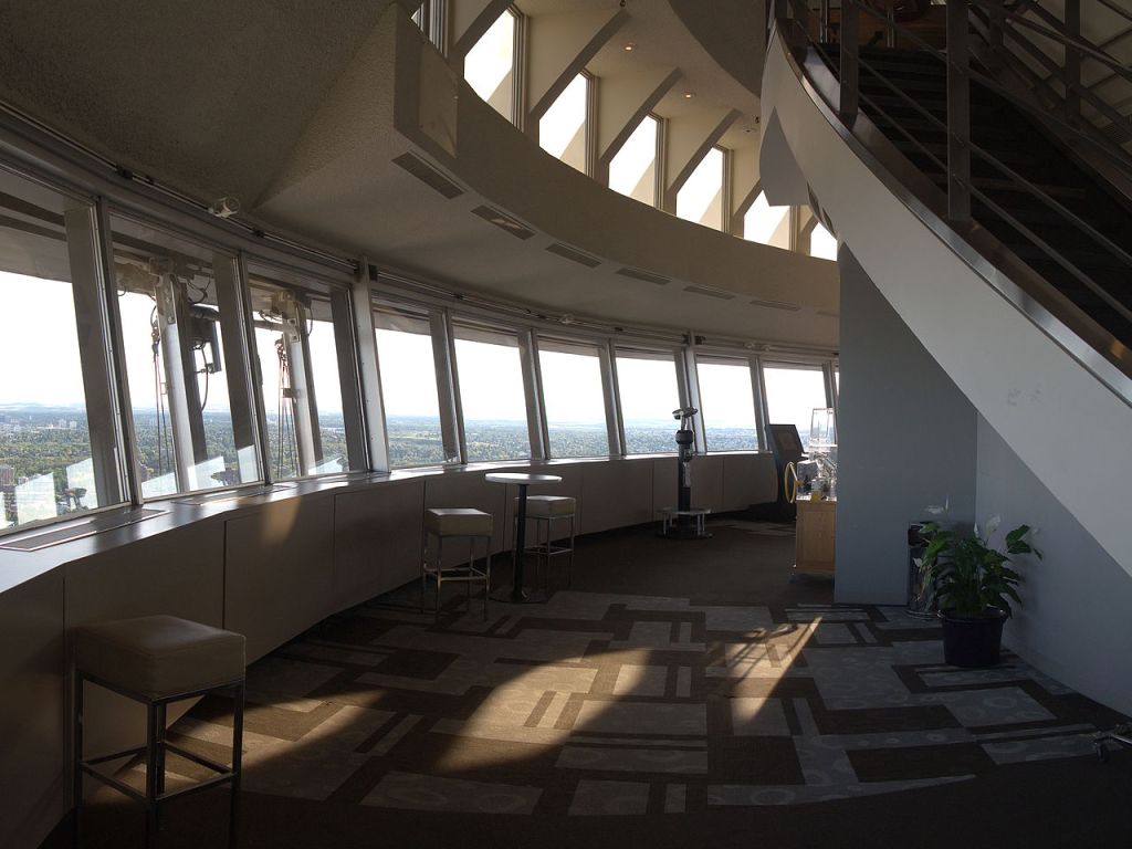
We alighted there and wanted to go to the top of the tower to get a panoramic view, but unfortunately the queue was too long and we did not have time to wait for our turn . So we walked around, clicked some pictures.
The CN tower is a telecommunication tower and is the tallest free standing( not held by wires)towerin Canada. But it is the fifth tallest free standing structure in the world.
The C N stands for Canada’s National tower.
It has an observation deck with floor to wall glass windows and a glass floor. Apart from that there is an observation point in the sky pod from where you may be able to see even Niagara falls or New York State in US on a clear day. One can also take a walk on the famous Edge walk…(a 1.5 mt wide ledge around the outer edge of the pod) attached to a safety harness. Apart from this there is a revolving restaurant in the tower which offers 360 degree views of the city and the landscape around.
The C N Tower
The entrance to the tower
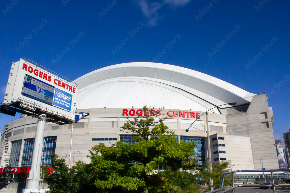
Next to CN tower is the Ripley’s Aquarium and the Roger’s center.
The Roger’s center is a domed sports arena. Its unique design allows for the roof to be retracted under favourable conditions. Roger’s center is the home of Toronto Blue Jays… the baseball team….and that day we did get to see fans trooping in to the center to watch a match….most of them in Blue garb. The cutest thing was a poodle also dressed in a bluejersey hopping along with its master to cheer the Blue Jays!!!
After we finished with these views we boarded the bus again and hopped off at Casa Loma. Casa Loma in Spanish means” Hill House” It is a building resembling a medieval castle set in a garden. Due to its unique architecture, it is a popular filming destination. It houses a museum. It is also a popular destination for wedding ceremonies for which it can be rented out.
Casa Loma
Next we visited Lawrence Market which houses a variety of vendors selling food, flowers etc. We took a break here for lunch.
Post lunch, we took the cruise to the Toronto Islands.
These are a chain of 15 small islands in Lake Ontario south of mainland Toronto. These are just offshore from the city’s downtown area. It houses the Billy Bishop Toronto city airport, an amusement park, yacht clubs and a public marina. This is a car free community and access to the mainland is only via ferry. Bicycles can be carried on the ferry.
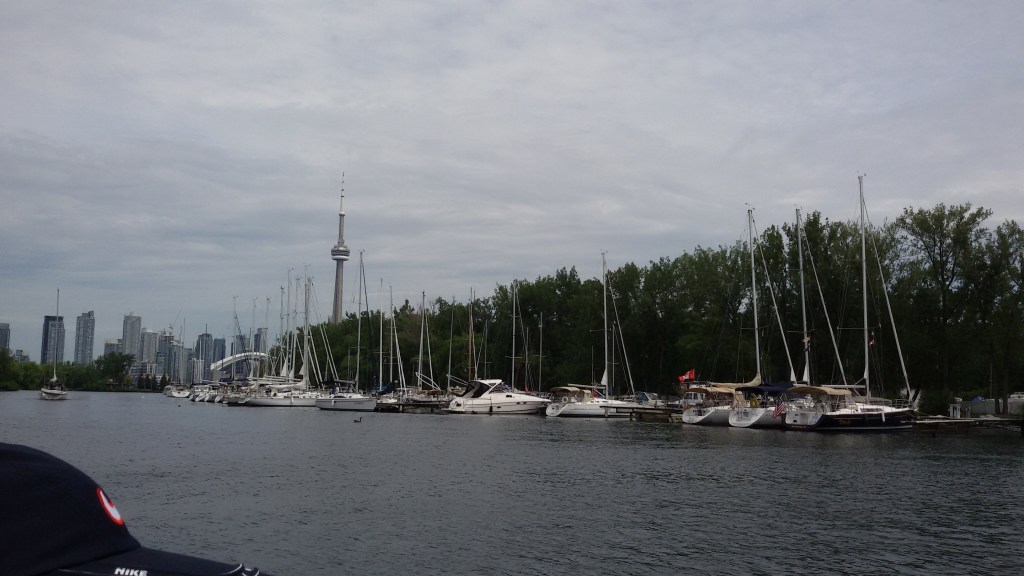
We took the ferry from the mainland and as we cruised along, got some great views of Toronto city.
View of Toronto city from the cruise
Yachts anchored at theToronto islands
After the cruise, we returned back to the station and took the train back home.
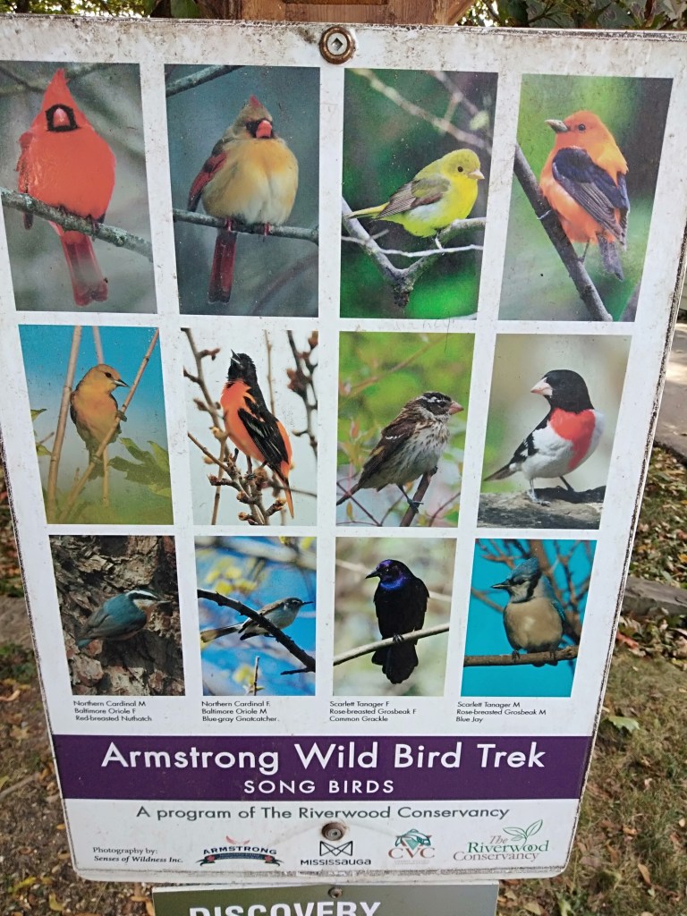
Riverwood conservancy was one of the places we visited
We took the local bus to Riverwood conservancy ; the 150 acre park..an urban oasis with accessible trails, creeks, wetlands and wildlife. The Credit River also flows by its borders. Children from the local schools often volunteer here for nature studies.Bird watching trails are also earmarked here.
It amazed me to see how such a serene and quiet place exists right in the middle of a buzzing metropolis! Also how the river water is so crystal clear and pristine….says a lot about the local people who refrain from maligning it!
The Credit River
Some views at Riverwood conservancy
Square one Mall is a high end shopping mall situated in downtown Mississauga. It is the second largest shopping center in Ontario. Needless to say, it houses many branded and high end shops and restaurants,Both the interior and exterior are beautifully designed.
At Square one Mall
Lakeshore Toronto
One morning ,we were dropped off at Lake shore by our friend and we spent a morning there. There are well landscaped gardens along the shores of Lake Ontario. Walking and cycling tracks draw the locals to this place. Being September, it was the start of fall and we did get a taste of fall colors on the maple trees.
Some pictures from our visit to Lakeshore
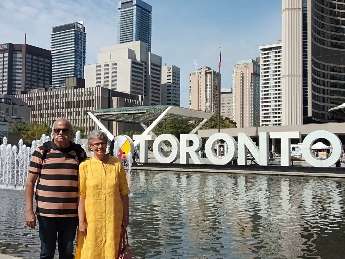
After a relaxing morning at Lake shore, we took a bus to downtown and visited Nathan Philips square; a plaza in front of the city hall . Here we saw the Toronto signage..one of the most photographed places in Toronto. It provides the backdrop to a reflecting pool which is used as a skating rink in winter. This square is the site of concerts, art displays, the farmer’s market, the winter festival of lights, and other public events. There are kiosks selling variety of food items and appeared to me like a picnic spot for the locals.
Nathan Philips Square
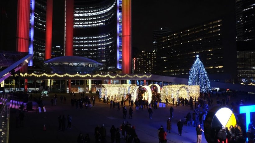
During Christmas time, this square is decorated and lit up. This is called the Cavalcade of lights.This officially marks the beginning of Christmas celebrations. A huge Christmas tree is also lit up. A stage is set up and many high profile music programs are held here. These celebrations last for almost 2 months.
Cavalcade of Lights
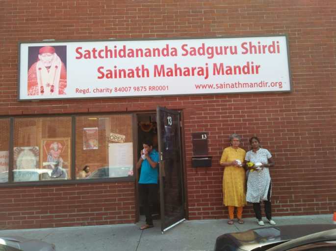
We also had the opportunity of visiting the Sai Baba temple in Mississauga. This temple looks unique from outside. In fact it is housed in a commercial complex and externally looks like an office. Once inside, it resembles any typical Indian Temple.
The entrance to the temple
There was another unique tourist destination we visited The Cheltenham Badlands.
Badlands is a geologic term for an area of soft rock devoid of vegetation and soil cover that has become molded into a rolling landscape of rounded hills and gullies
An area of approximately 0.5 km, it features essentially clay that is easily eroded by water. The Queenstone shale has brick red to maroon color. Formed as a result of tectonic activity hundreds of years ago, this region was used extensively for cattle grazing. The unscientific agricultural and grazing practices over the years added to the erosion by nature and led to this formation.There are trails here where you can explore the badlands. But entry on to this fragile shale is prohibited.
The Cheltenham Badlands
Since we stayed at Toronto for a considerable period of time, and moved around and interacted with some locals , we really got to experience day to day life here…would like to share some pictures…a sneak peek into the life of immigrant Indians in Canada…take a look
There was a reasonably big park with lot of recreational activities that we used to visit ….close to where we stayed….. Sandalwood park. Some pictures…
At Sandalwood park
We had a small picnic with some Indians one evening at the park. Also attended a birthday party hosted by an Indian family…take a look
A picnic and a birthday party
Well, I hope I have conveyed the essence of Toronto to all of you…..
From Toronto, we also visited Ottawa,the capital of Canada, and Montreal and Quebec which are some important cities in Canada. My next blogs will cover my experiences in these cities…
Most of you would agree that Niagara falls would be a nice place to start this series…it literally sits on the US-Canada border!!!
Having seen it….or rather experienced it twice; I can tell you, its simply amazing!!!
We visited Niagara falls from Toronto . (pictures in this blog are a mix from both the visits and some keen eye among my readers may notice it) .Since the view of the falls from the Canadian side is way better than from the US side, we decided to do it from Canada.
A brief on the falls before we get to the actual travel and attractions:
The Niagara falls is a name used for a group of three waterfalls at the border between US and Canada.The largest…the horseshoe falls is located in Ontario province in Canada while the American falls and Bridal Veil falls are on the American side of the border. These falls are formed on the Niagara river as it empties Lake Erie into Lake Ontario. Niagara falls was formed at the end of the ice age when the Great lakes carved its path through the Niagara escarpment on its way to the Atlantic ocean.
Some Statistics and Comparisons
There are about 500 waterfalls in the world taller than Niagara.
Angel falls in Venezuela with a height of 979 metres is the tallest waterfall in the world.
Victoria Falls on the Zambezi river in Africa is 108 metres high but is very broad….a width of 1708 m!!!!
The Iguazu falls in South America bordering Argentina and Brazil is a conglomerate of 275 waterfalls….becoming the world’s largest waterfall system
In spite of all this, Niagara is so popular. Have you wondered why?
Niagara has a height of only 51 metres. But the volume of water that flows is very high. 2832 tonnes of water flows over the falls per second. It is this peculiarity that makes it so popular
The water at Niagara is green in color due to the enormous amount of minerals being swept over due to its erosive nature.
Where does the water come from?…this will be the next question in everyone’s mind..
From the Great Lakes. The Great Lakes is the largest collection of freshwater in the world…18% of the fresh water.The water flows from streams and rivers that empty into the Great Lakes, from Lake Superior down through Niagara to Lake Ontario and then into the St. Lawrence River and finally Atlantic Ocean
Future Of Niagara?
The falls continuously erode. At a rate of 1 to 1.5 metres per year. Rock falls occur regularly at the edge of the falls. Flow control and diversion for hydroelectric power has managed to reduce the natural rate of recession. Climate change is also affecting Niagara. All things considered, scientists speculate that perhaps 2000 years from now, the American falls would dry up. The falls could be reduced to a series of rapids…
Well…that is far far away in time….for now, enjoy the falls as I take you along…
Coming to our trip....
We were in Brampton,Toronto and were hosted by a close friend who drove us up to Niagara falls city which is about 130 km. The drive was beautiful and we passed lake Ontario on the way. Had a short coffee break at a Tim Horton’s outlet at Grimsby.
Tim Horton’s is a chain of restaurants you find all over Canada.I must tell you, the coffee at Tim Horton’s is just too good.Highly recommended for future visitors!!
Reached Niagara by noon and checked into Embassy Suites located bang opposite the falls …..it offers lovely view of the falls.
Our hosts at Toronto….with the falls in the background
Rested for sometime and visited the falls in the evening.
As we walked up to the falls, there are a few nice view points along the roadside from where you get a panoramic view of the falls like the one in the picture below.
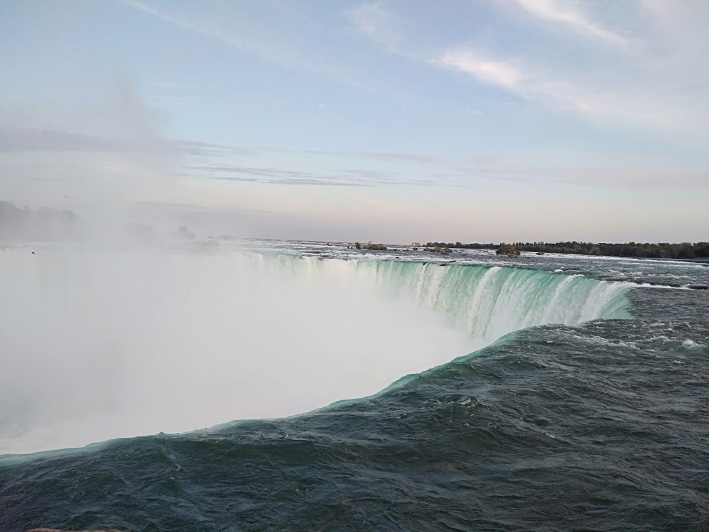
The Horseshoe falls at Niagara
As you reach closer to the falls…the sound of the water builds up the excitement and when you actually stand by the railings on the footpath and look at it; it’s a life time experience!
The sheer size of the falls and the volume of water that gushes by every moment is awe inspiring!!No amount of description will match the visual treat…so just putting some pictures for you to enjoy….
Some pictures depicting the sheer size and volume of water flowing by…..
A short video of the Horse shoe falls
Wanting to get an ariel view of the falls, we headed to Skylon Tower.
Skylon Tower is an observation tower in the Niagara falls city in Ontario (Canada) that overlooks both the American falls and the horseshoe Canadian falls and the Niagara River.
An aerial view of the horseshoe falls with the cruise boat sailing towards the falls
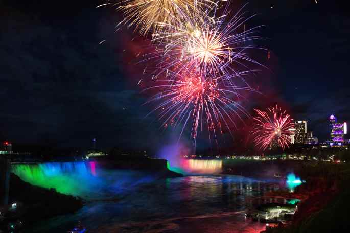
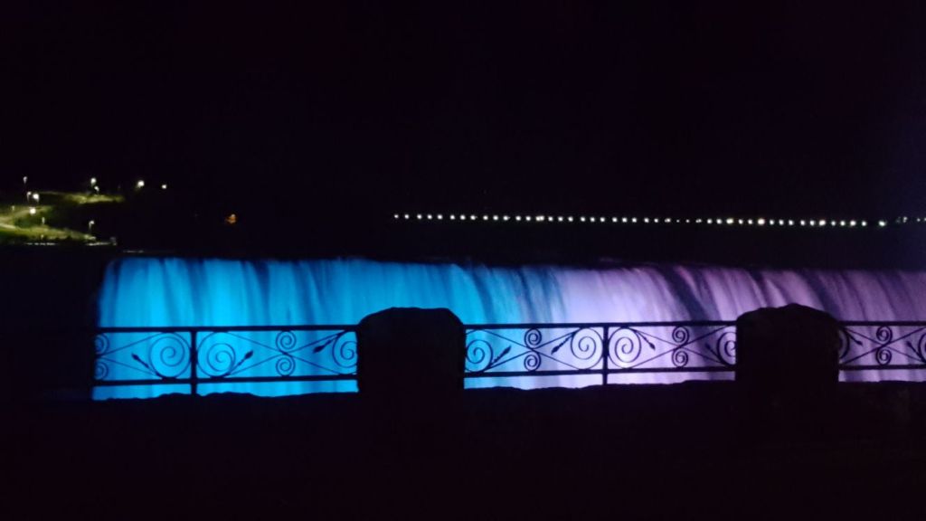
After that we returned to the falls in time for the illumination of the falls. How is this done?
Hundreds of LED lights are housed in three locations across the Niagara gorge. Together these lights create a breathtakingly beautiful view. This takes place daily at dusk.On special occasions they are lit up in specific colors too!
The illuminated falls is a great sight to behold…
Some pictures…
Illuminated falls
Niagara Fireworks
A fireworks display over the brink of the falls is held in summer and also during the winter festival and other special occasions
Fireworks over the falls
After a spectacular view of the illuminated falls, we returned to our hotel
Day 2
After breakfast, we again headed for the falls..this time to get closer…to get to the bottom of the falls. We then took the Hornblower cruise to the bottom of the falls. Each of us was provided with a red rain coat and we cruised towards the falls. As we came close to the falls, there was lot of spray and the raincoat protected us. However, taking pictures was almost impossible due to the movement of the boat and the spray..But the experience was exhilarating…to say the least..
If you do the same activity from the US side, you use the Maid of the Mist cruise and you are in blue coats!!
After that we walked up to see more of the American side of the falls…much smaller than the Canadian one..
The American Falls. The cruise boat heading to the bottom of the fallsis also seen
The buildings you see in this picture are in USA…the falls are located just at the border.
We also saw the Rainbow bridge the bridge across the Niagara river connecting the land borders of Ontario in Canada with New York in USA.
If you zoom and see…you will see the Canadian flag closer to you and the American farther away…There is a full fledged immigration station functioning here for people crossing over..
After that, we walked around Niagara falls city…
Though the falls is the highlight of this place,Niagara falls city has lots more on offer…. it is a full blown entertainment city too.There are plenty of Casinos, theme parks, game centres and various entertainment avenues here…including the Niagara wheel…a giant wheel which also offers great views as one ascends ….
A casino in Niagara falls city
During our walk at Niagara falls city
Besides this there are helicopter rides that take you over the falls. As we sat around the beautifully landscaped park across the falls, we saw this activity taking place too.
We spent our second evening at Niagara again enjoying the illuminated falls and returned to the hotel.
Next morning we took a bus from Niagara falls bus station to Brampton Terminal and then home…ending a wonderful visit to this wonder of nature…
Next week we meet at Toronto….
Till then…good bye
Don’t forget to subscribe to my blog below
For those of you who would like to see some awesome views of Victoria Falls…in comparison to Niagara, do visit